We are developing a spatial framework and online application to identify priority locations to promote the recovery of Endangered Species Act (ESA)-listed corals and their associated ecosystems in the Indo-Pacific. This project is in collaboration with NMFS Pacific Islands Regional Office.
Why We Care
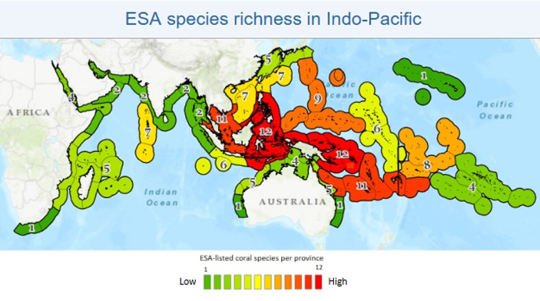
In 2014, the NOAA NMFS Pacific Islands Regional Office (PIRO) listed 15 Indo-Pacific reef-building coral species as threatened under the ESA (79 FR 53851). Specifically, these 15 listed species include: Acropora globiceps, A. jacquelineae, A. lokani, A. pharaonis, A. retusa, A. rudis, A. speciosa, A. tenella, Anacropora spinosa, Euphyllia paradivisa, Isopora crateriformis, Montipora australiensis, Pavona diffluens, Porites napopora, and Seriatopora aculeata.
Coastal and marine resource managers need high-quality and reliable map products to make smart management and resourcing decisions. Understanding coastal, pelagic, and benthic habitats can allow stakeholders to make more comprehensive planning decisions. Often, funding is limited, and therefore, decisions about how and where to deploy resources need to be made efficiently.
To promote coordination and fill these information gaps, NOAA NCCOS’s spatial prioritization widget tool provides a quantitative spatial framework to help agencies efficiently allocate resources and leverage partnership contributions to meet collective goals. This framework spatially captures and summarizes answers to questions such as:
- Where – What locations should be considered for ESA coral species and their reef ecosystem recovery efforts? Which are most important?
- Why – Why are these locations important?
- When – How quickly should conservation and recovery activities occur?
- What – What types of information exist and what types are still needed for effective conservation and recovery implementation?
- Who – Who are potential project partners for these activities?
This approach has been successfully applied by NCCOS in regions around the U.S., including in the U.S. Pacific Territories (American Samoa, Guam, and Commonwealth of the Northern Mariana Islands), California, Oregon, Washington, U.S. Caribbean, Lake Michigan, South Atlantic, and New York.
What We Are Doing
NCCOS will assist the NOAA National Marine Fisheries Service (NMFS) Pacific Islands Regional Office (PIRO) in identifying priority locations and partnership opportunities to promote the recovery of 15 ESA-listed corals and their associated ecosystems in the Indo-Pacific. This work will be conducted in collaboration with NMFS PIRO, which is responsible for developing and implementing a recovery plan for these ESA coral species and their ecosystems. Since these species are present in the waters of over 60 countries, NCCOS will facilitate an online spatial prioritization to identify and rank potential locations (within a single subregion or subset of a subregion; Figure 1) within PIRO-identified priority areas, specifically ecoregions across the Indo-Pacific, for targeting coral recovery efforts.
We will apply an analytical approach similar to the one used in the most recent shallow coral reef prioritization effort. Participant priorities will be entered into an online portal using the existing process and spatial prioritization online widget developed by NCCOS. Results will be analyzed using clustering or other relevant techniques to identify significant relationships between priorities, issues, and ranking criteria. Spatial patterns will be mapped using frequency and hotspot analysis. Preliminary results from the prioritization process will be reviewed and finalized by partners. Final prioritization results and maps will be compiled in a technical report. These data and final report, along with associated GIS data, will be archived through NOAA National Centers for Environmental Information, and will also be made publicly available through an online web mapping application (currently in development).
Benefits of Our Work
The work described here will help develop and enhance partnerships in the Indo-Pacific region by utilizing NCCOS’s proven experience conducting spatial prioritizations to:
- help resource agencies and communities identify areas of overlapping data needs;
- promote coordination among participating organizations;
- enable partners to leverage resources to fill their most pressing data needs and information gaps; and
- develop and enhance strategic partnerships in the Indo-Pacific region.