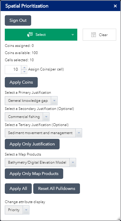
The Spatial Prioritization Widget is a tool to gather mapping priorities from stakeholders in a study area. This customizable tool can be configured to identify not only the desired locations and the temporal priorities of the respondents, but also their rationales to justify these decisions or the type of mapping products they need. The data can be further analyzed to identify consensus areas of highest priority.
Download Widget (WAB version 2.21)
Download Documentation
Download Sample Prioritization Grid mxd and Geodatabase (ArcMap 10.6)
Why We Care
Only a small fraction of the ocean’s seafloor have been mapped with modern, high resolution products such as multibeam sonar, but resources are limited to fully map the remaining areas. High priority areas need to be identified through a collaborative process to meet NOAA’s “Map once, use many times” principle.
 What We Did
The Spatial Prioritization Widget is a tool built for Esri’s Web AppBuilder, and is designed to be used in participatory GIS projects by stakeholders who need to evaluate proposed mapping efforts. Using hosted feature services and user accounts on ArcGIS Online, the tool gathers the spatial and temporal requirements of the stakeholders. It can be customized to gather additional information, such as the justifications for the data collections and the type of remote sensing platforms to be used. The tool can be integrated with other widgets in the Web AppBuilder portfolio to create a rich web application to explore other data associated with the project to understand the limitations of existing information, gaps in existing maps, and help identify priority areas for future mapping. The prioritization choices are automatically saved on ArcGIS Online databases, which can be exported and analyzed to identify high priority areas and coordinate the planning,acquisition, and sharing of the mapping data.
Benefits of Our Work
This process has been used in Long Island Sound, Washington State, Lake Michigan, Lake Huron, and the US Caribbean to identify high priority mapping areas which were then used to direct NOAA vessels on subsequent mapping missions. In Washington, after a prioritization exercise was completed in 2015, NOAA’s Integrated Ocean and Coastal Mapping Office (IOCM) mapped these high priority areas over the following two years. In 2018, the state conducted further workshops to identify additional priority mapping areas based off the success of the previous exercise. Other organizations have utilized the widget in their own spatial prioritization projects. IOCM is conducting a nation-wide prioritization of nearshore and offshore ocean regions and the Great Lakes. The Florida Fish and Wildlife Conservation Commission has prioritized all Florida state water. Alaska’s Department of Natural Resources conducted a coastal prioritization of their state waters.
Next Steps
This tool will be utilized in several upcoming projects, including in Lake Superior and other Great Lakes projects.
