In 2012, the U.S. Naval Facilities Engineering Command (NAVFAC) Marianas developed a resource plan for the Commonwealth of the Northern Mariana Islands (CNMI). The purpose of this plan is to mitigate impacts of the U.S. Navy’s mission on submerged lands under their control. NAVFAC requested that NCCOS develop an updated habitat map for these submerged lands around Navy Base Guam (NBG) to help inform their resource decisions and execute recommendations in this plan.
Why We Care
The U.S. Naval Base Guam (NBG) is located in Apra Harbor, Guam. Apra Harbor is divided into Inner and Outer areas. NBG operates three wharfs in the Outer Harbor and several other wharfs in the in the Inner Harbor. Apra Harbor is also used by the Navy for a variety of training exercises and activities, which have the potential to impact nearby benthic habitats, including coral reef ecosystems. Activities and actions that potentially affect coral reef ecosystems must be mitigated under Executive Order 13089.
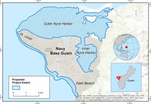
In 2012, the U.S. Navy developed a resource management plan—called an Integrated Natural Resources Management Plan (or INRMP)—for CNMI in collaboration with various federal and territorial agencies. This plan recommends potential ways to mitigate the potential impact of the Navy’s activities on coral reef ecosystems. Local staff from NAVFAC Marianas requested that a baseline benthic habitat map be created for submerged lands around NBG, including Outer Apra Harbor, Point Udall and south to Dadi Beach and potentially Inner Apra Harbor (Figure 1). This updated map and associated products will be used to inform monitoring and management decisions in the harbor, and help NAVFAC execute the INRMP for the Joint Region Marianas.
What We Will Do
NCCOS will integrate different imagery sources to produce baseline benthic habitat map products for submerged lands around NBG. Updated, readily available satellite images of the project area will be collected and processed. This imagery will be combined with sound navigation and ranging (SONAR) depth and intensity data to develop a new habitat map from the shoreline to approximately 70 m depths. The resulting habitat map will depict the distribution of key biological and geomorphological habitats using a classification scheme tailored meet to NAVFAC’s informational needs and the coastal and marine ecological classification standard (CMECs). NCCOS will collect underwater photos and videos in partnership with local experts in CNMI. Some of these photos and videos will be used to develop the habitat map products. A separate subset of these photos and videos will be used to independently assess the performance and accuracy of the resulting habitat map products. Local experts from the jurisdictional community will also be asked to evaluate the habitat map products before they are finalized. A final report, web map and final habitat products will be made publicly available for download and for viewing online at the end of the project.
Benefits of Our Work
This work was funded by NAVFAC Marianas and will be conducted in partnership with NAVFAC, CNMI territorial government, NOAA National Marine Fisheries Services, NOAA Office of Coastal Management and the University of Guam. The habitat products developed during this project will provide a critical spatial framework to mitigate potential impacts of the U.S. Navy’s mission on submerged lands around NBG. Future projects or management actions in these submerged lands will benefit greatly from the updated imagery, habitat map products, and underwater photos and videos compiled during this project. These data sets will inform decisions about mission training activities, resource monitoring, protected species, land-based sources of pollution and scientific research moving forward. This project and resulting products will also help support other marine management efforts by the CNMI territorial government and other local federal agencies.