NCCOS developed a spatial framework to identify common research priorities across partner organizations which has been successfully implemented on the U.S. West Coast, Florida, and Lake Michigan. NCCOS applied this well-established method to the U.S. Caribbean territories of Puerto Rico and U.S. Virgin Islands. This project will help inform research and management decisions to help organizations efficiently leverage spatial and visual mapping priorities.
Why We Care
Spatial information about the seafloor is critical for decision-making by marine research and management organizations. These organizations are tasked with ensuring safe navigation, sustainable fisheries, smart renewable energy, and sound ecological stewardship and conservation in U.S. coastal and marine waters. Coordination among these research and management organizations can help them efficiently leverage resources to map and explore unknown seafloor areas in support of their individual objectives, mandates, and missions. Effective coordination requires that these organizations understand where and when their priorities overlap with others operating in the same regions.
To help promote coordination and fill information gaps, NOAA NCCOS developed a spatial framework and web-based tool to identify common spatial and management priorities across partner organizations. This framework spatially captures and summarizes answers to questions such as:
- What locations are important?
- Why are they important?
- How quickly is data collection needed?
- What data products are needed most?
This approach has been successfully applied by NCCOS in various regions around the U.S., including the West Coast, Alaska, Lake Michigan, South Atlantic, offshore Southern California, New York, and Washington State. Here, NCCOS will use this well-established spatial process to help participating organizations in the U.S. Caribbean to identify seafloor mapping and visual survey priorities in Puerto Rico and the U.S. Virgin Islands (USVI).
What We Did
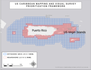
This project’s objective was to identify and summarize spatial priorities for seafloor mapping and visual surveys for Puerto Rico and USVI. Seafloor mapping was defined to include the use of sonars, LiDAR, satellite imagery, and optical imagery from a variety of sources to make maps of the surficial seabed and/or sub-bottom features. Visual surveys included underwater video collection using towed camera sleds, remotely operated vehicles (ROVs), and autonomous underwater vehicles (AUVs). This prioritization did not include in situ sampling, cores, bottom grabs, etc. Other relevant, readily available GIS data sets (e.g., essential fish habitats, habitat areas of particular concern, recreational and commercial fishing areas, etc.) were provided in the prioritization application from existing data warehouses or those provided by partners in readily-accessible GIS formats. These data sets were viewed by participating organizations to help guide their selection of high priority areas.
We applied an analytical approach similar to the one used in the recent West Coast Prioritization effort. Participants entered their priorities into an online portal using a spatial prioritization widget developed by NCCOS. Results were analyzed using clustering and other relevant techniques to identify significant relationships between priorities, issues, and ranking criteria. Final prioritization results and maps will be compiled into a report that will help guide future mapping and visual survey activities in the U.S. Caribbean. The results from this effort can also be seen in this NCCOS News item.
Benefits of Our Work
This project was funded by NCCOS and supported by NOAA’s Coral Reef Conservation Program (CRCP). The work described here will benefit the U.S. Caribbean community, resource agencies, and other participating organizations by: (1) helping organizations better understand how their priorities align with other U.S. Caribbean partner needs, (2) better positioning participating organizations to more efficiently coordinate across projects, and (3) better enabling partners to leverage assets and resources to fill their most pressing data and information gaps in Puerto Rico and USVI.