Many organizations need imagery, and elevation and depth data to effectively manage our nation’s coastlines. However, coastal areas are expensive and challenging to map using conventional technologies. Here, we are testing the ability of commercially available unmanned vehicles and photogrammetric software to fill this need. Data from these efforts will help identify guidelines for payloads and processing workflows, as well as environmental and operational limitations for coastal mapping at NOAA.
Why We Care
U.S. shorelines are busy and dynamic places, encompassing a wide range of ecologies, geologies, hazards, human uses, and political jurisdictions. Several organizations, including NOAA, need imagery, and elevation and depth data to inform management decisions in the coastal zone. Although there is a great need for coastal data, many nearshore areas are expensive, challenging, and even dangerous to map with existing, manned technologies, resulting in information gaps along the coastline.
Small unmanned aerial systems (sUAS) may offer a potentially safe and effective way to fill these critical gaps, since they are capable of producing centimeter-scale photographs in nearshore environments. Elevations and depths can be derived from these photographs using Structure from Motion (SfM) software. SfM uses overlapping photographs (collected by the sUAS) and photogrammetry to calculate the heights and depths along the coastline. Combining sUAS and SfM could potentially fill nearshore data and information gaps accurately, safely, and cost effectively, providing comprehensive and timely information to coastal managers and planners. However, additional research is needed to identify optimal payloads and processing workflows, as well as to define the environmental and operational limitations of these systems before they are implemented more widely across NOAA.
What We Are Doing
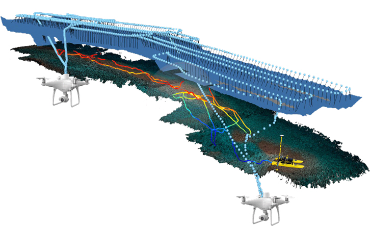
NCCOS and its partners are using sUAS and SfM to map nearshore depths and elevations. The researchers first tested sUAS and SfM in St. Croix, U.S. Virgin Islands (USVI), to identify optimal sUAS payloads and SfM processing workflows. These tests occurred in two marine managed areas, including Buck Island Reef National Monument and the St. Croix East End Marine Park.
Initial results were promising, leading to additional research on Santa Cruz Island, California. The objective of this follow on project was to understand the operational and environmental limitations of sUAS and SfM to map coastal elevations and depths in more remote locations under more challenging environmental conditions. The team conducted the tests on land owned by The Nature Conservancy and on submerged lands under the jurisdiction of the Channel Islands National Marine Sanctuary. The group also tested an Autonomous Surface Vehicle (ASV) along the Santa Cruz Island coast. The researchers measured depths using a Sound Navigation and Ranging (SONAR) sensor mounted on the ASV. Then, they used these depth measurements to independently validate the depths derived from SfM, and to better understand the benefit of these surface vehicles for nearshore bathymetric mapping.
The lessons learned and final results from this research will be compiled in a technical report. The report will help guide future coastal mapping using sUAS and SfM at NOAA, and will be a companion to the NOAA Office of Coast Survey’s procedures manual for operating sUAS from NOAA hydrographic ships.
NCCOS is conducting this research in close collaboration with Oregon State University, NOAA’s Office of Coast Survey, NOAA’s National Geodetic Survey, and in coordination with local partners, including the USVI territorial government, the National Park Service, NOAA’s Office of National Marine Sanctuaries, The Nature Conservancy, and the University of California Santa Barbara.
Impact/Benefits of Our Work
The use of commercially available unmanned vehicles has become increasingly common in coastal areas. To encourage their increased use at NOAA, Congress passed the Commercial Engagement through Ocean Technology (CENOTE) Act in 2018. This act encourages NOAA to advance its use of unmanned vehicles to meet its mission, and to better coordinate unmanned vehicle research and development with other federal agencies, academic institutions, and commercial entities. The work described here aligns with this congressional mandate and provides an example of how commercially available unmanned technologies and academic partnerships can be leveraged by NOAA to more effectively meet is mission and goals.
This work was funded by NOAA’s Unmanned Aircraft Systems Program. The research is designed to support the NOAA Office of Coast Survey’s (OCS) nautical charting needs in shallow (<10 m) waters. OCS is developing procedures to operate sUAS from hydrographic vessels. The methods described here will accompany these operational procedures, and together will help move this technological approach from research toward operations at NOAA. In addition to supporting OCS’s needs, there has been substantial interest in sUAS applications beyond nautical charting from other NOAA offices, federal agencies, state agencies, and non-governmental organizations. This interest has ranged widely from mapping and monitoring coastal habitats to surveying marine animals to observing human activities in coastal environments. Efforts are currently underway at NCCOS to build on the research described here and continue to design and test new applications for commercially available unmanned vehicles.