 An official website of the United States government.
  Official websites use .gov
A .gov website belongs to an official government organization in the United States.
Official websites use .gov
A .gov website belongs to an official government organization in the United States. Secure .gov websites use HTTPS
A lock or https:// means you’ve safely connected to the .gov website. Share sensitive information only on official, secure websites.
Secure .gov websites use HTTPS
A lock or https:// means you’ve safely connected to the .gov website. Share sensitive information only on official, secure websites.We are working to inform and improve coastal resource management and resilience to extreme weather events (e.g., Nor’easters and hurricanes) whose impacts are magnified with sea level rise. The project uses models to quantify the impacts of future storm and sea level rise scenarios on ecosystem and infrastructure vulnerability in five national parks and two national wildlife refuges in New England.
Why We Care
Coastal communities and critical habitats are at increased risk due to sea level rise. Adapting to sea level rise and extreme weather conditions in our changing climate is a growing concern. In New England, extratropical storm events with strong winds and heavy precipitation (commonly called nor’easters) are the most common coast-shaping storms, followed by hurricanes. There is limited information on how the impact of both types of storms may be amplified with a changing climate and sea level rise. This information gap impedes proper planning for the future and is likely to lead to under-informed and ineffective adaptation measures.
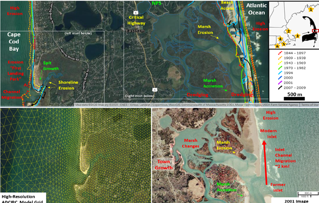
(Upper half) Eastham, Massachusetts, and surrounding Cape Cod National Seashore (eastern side) project site with historical shorelines and coastal changes indicated; right-side inset shows location of project study sites. (Lower left) example of ADCIRC model grid. (Lower right) Inlet movement and marsh changes are highlighted. Credit: I. Ginis, University of Rhode Island.
What We Are Doing
The project includes several study sites at five national parks (Acadia, Boston Harbor Islands, Cape Cod, New Bedford Whaling, and Roger Williams Memorial) and two national wildlife refuges (Ninigret, and Trustom Pond) in three New England states (Maine, Massachusetts, and Rhode Island). While all of these sites have critical risk today and increasing concern for the future, each location has different management needs, data availability, and planning efforts. The project is tailored to meet the specific needs of each site, as determined through interactions with key stakeholders.
The project team is using a suite of existing physics-based numerical models (Adcirc+Swan, Funwave, Xbeach, and SLAMM) to quantify the impacts of future storm and sea level rise scenarios on ecosystem and infrastructure vulnerability. Two sites include mitigation strategies with and without implementing site-specific natural and nature-based features (NNBF). The team will develop an online portal to share model output with the scientific and management communities.
The project uses a three-tiered, stakeholder-driven process to facilitate and enhance collaborations.
Benefits of Our Work
The project engages managers and staff at parks, refuges, local and state governments, and nonprofits in a collaborative and iterative process to ensure models, results, vulnerability assessments, and accompanying 3D visualizations support specific stakeholder management concerns and inform management decisions. The place-based information and insights from this project promote wiser use of resources to improve coastal resilience and protect communities (people and infrastructure) and their ecosystems (habitats, resources, and services).
The project is led by Dr. Isaac Ginis of the University of Rhode Island (URI) with URI co-partners John Patrick Walsh, Stephan Grilli, Pamela Rubinoff, Annette Grilli, and Peter Stempel of Penn State University. Collaborating organizations include the Schoodic Institute and the National Park Service. The project is part of NCCOS's Effects of Sea Level Rise Program (ESLR) Program.