NOAA has partnered with NASA, the U.S. Environmental Protection Agency, and the U.S. Geological Survey to transform satellite data designed to probe ocean biology into information that will help protect the American public from harmful freshwater algal blooms.
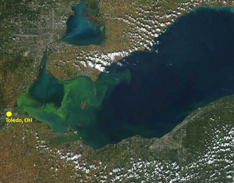
Harmful algal blooms are a worldwide environmental problem, costing millions of dollars annually. These toxic events threaten public health, drinking water, tourism, fisheries, and protected and endangered species. In August 2014, officials in Toledo, Ohio, banned the use of drinking water supplied to more than 400,000 residents after it was contaminated by an algal bloom in Lake Erie.
The new $3.6 million, multi-agency effort will use ocean color satellite data to develop an early warning indicator for toxic and nuisance algal blooms in freshwater systems and an information distribution system to aid expedient public health advisories.

MODIS satellite image of 2014 algal bloom in Lake Erie. Credit: NOAA Great Lakes Environmental Research Laboratory.
NOAA and NASA pioneered the use of satellite data to monitor and forecast harmful algal blooms. Satellites allow for more frequent observations over broader areas than water sampling. The satellite data support NOAA's existing forecasting systems in the Gulf of Mexico and Great Lakes.
'Observing harmful algae is critical to understanding, managing, and forecasting these blooms,' said Holly Bamford, acting NOAA assistant secretary for conservation and management and deputy NOAA administrator.'This collaboration will assure that NOAA's efforts will assist the coastal and inland public health officials and managers across the country to distribute this information to the community in an easily understandable fashion, making them more resilient to environmental events.'
For more information, contact Richard.Stumpf@noaa.gov.
 Official websites use .gov
A .gov website belongs to an official government organization in the United States.
 Secure .gov websites use HTTPS
A lock or https:// means you’ve safely connected to the .gov website. Share sensitive information only on official, secure websites.