Six weeks after the scientific study Large flood risks in Los Angeles, California was published, Janice Hahn, Chair of the LA County Board of Supervisors, referenced these findings in a motion directing the county to assess its stormwater infrastructure and address issues in the current system. Her motion was immediately and unanimously adopted.
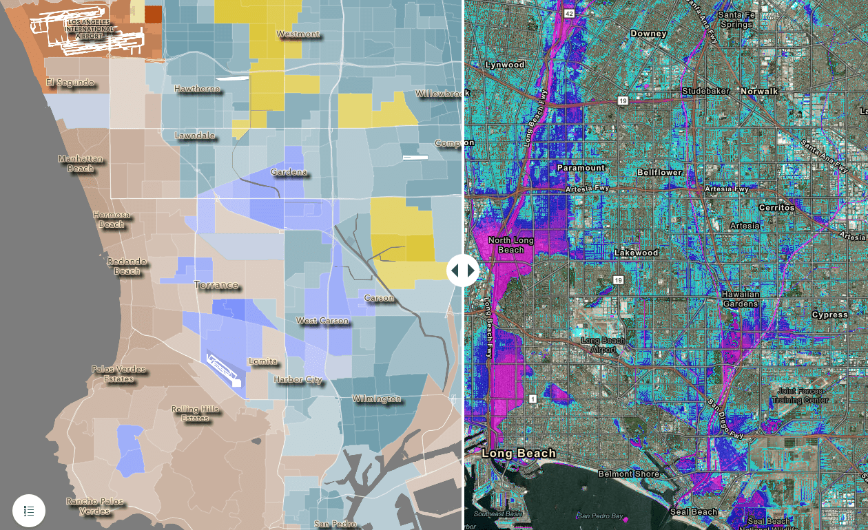
The study inspiring Hahn’s motion, funded in part by NOAA, employs an innovative new urban flood risk modeling system to identify the severity and extent of flooding faced by residents within a refined 100-year flood zone. Notably, this modeling effort identified flood risk far greater than previous, federally-defined floodplains. When combined with socioeconomic information, results characterized disproportionate risk to vulnerable communities.
The study’s lead author, Dr. Brett Sanders from the University of California, Irvine, attributes the unusually quick response of local leadership in part to the team’s community-engaged research approach as they interpreted their initial model results in the context of local planning. Consulted stakeholders included community groups, policymakers, county flood control groups, and California’s Department of Water Resources. National media coverage likely also played a role in the uptake of research findings, with both the LA Times and New York Times reporting on the study. Lastly, the research team also took steps to make their findings relevant and accessible to the general public and local decision makers. A StoryMap, published within a week of the original study, includes interactive, high-resolution graphics showing flood risk on a house-by-house basis. Fine resolution data is crucial to assessing the consequences of flooding and informing solutions at the scale of individual communities and neighborhoods.
Hahn’s motion will result in an assessment of LA County’s stormwater infrastructure, taking into account climate resilience. The motion also calls for additional efforts to inform LA county residents of changing climate impacts and flood risk mitigation efforts. Meanwhile, Sanders hopes to explore a suite of solutions to reduce the identified flood risks, while characterizing the distribution of costs and benefits associated with different actions. Sanders and his team are also interested in repeating their detailed modeling of LA in other major cities across the United States to evaluate the magnitude and extent of flood risk.
This project is part of NCCOS’s Effects of Sea Level Rise Program (ESLR) Program; find out more about the project here. This project is led by Dr. Brett Sanders (U.C. Irvine).