There is growing evidence that flood risks in the United States have historically been underestimated, and will disproportionately impact individuals within low-wealth and marginalized communities. New research offers the Los Angeles region an understanding of Where they are at risk of flooding, Who and What is at risk, Why they are at risk, and When risk increases under sea level rise and climate change.
A recently published study, in part funded by NOAA, focused on a more complete range of risks in Los Angeles, California than had been considered in the past, to quantify the magnitude of flood risk and characterize who would be impacted within a 100-year flood zone. The science team, led by U.C. Irvine, used a quantitative framework that intersects flood hazards from rainfall, streamflow and storm tides with measures of exposure and vulnerability.
They found that between 197,000 and 874,000 people and between $36 and $108 billion in property value would be exposed to flooding greater than 30 cm within the 100-year flood zone. This represents risk levels far above federally defined floodplains and similar to the most damaging hurricanes in U.S. history. These risks are disproportionately higher for non-Hispanic Black and disadvantaged populations, burdening communities that may have greater challenges recovering and reinforcing socioeconomic disparities. The analysis framework they developed creates opportunities for transparently reducing flood risks in urban areas.
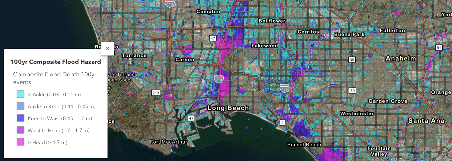
The science team also developed a StoryMap to accompany the research paper that allows users to explore the 100-year flood map in detail, evaluate the magnitude of flood risk in regions of the city and preview the demographics for those vulnerable regions. The underlying approach and outputs from work presented in the research paper and story map will lay a foundation for improving holistic regional planning that takes into account a greater number of considerations for decision making.
This detailed modeling of flood hazards in Los Angeles enables new understanding of the full extent and distribution of flood exposure and its variability, which could be replicated for major cities across the U.S.
This project is part of NCCOS’s Effects of Sea Level Rise Program (ESLR) Program; find out more about the project here. This project is led by Dr. Brett Sanders (U.C. Irvine). Their recent paper in the journal of Nature Sustainability includes the following authors: Jochen E. Schubert , Daniel Kahl, Amir AghaKouchak, Richard Matthew, Nicola Ulibarri, and Steven Davis (U.C. Irvine); Katharine Mach (University of Miami); David Brady (U.C. Riverside); Fonna Forman (U.C. San Diego).
Citation: Sanders, B.F., Schubert, J.E., Kahl, D.T. et al. Large and inequitable flood risks in Los Angeles, California. Nature Sustainability 6, 47–57 (2023). https://doi.org/10.1038/s41893-022-00977-7