We are working to inform and improve coastal resource management and resilience to extreme weather events (e.g., Nor’easters and hurricanes) whose impacts are magnified with sea level rise. We will use models to quantify the impacts of future storm and sea level rise scenarios on ecosystem and infrastructure vulnerability in municipalities like Charlestown, Rhode Island.
Why We Care
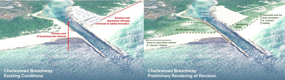
Coastal communities like Charlestown, Rhode Island, are facing increasing flood risk and erosion from nor’easters, hurricanes, and sea level rise. Long-term cultural, economic, and environmental resilience depends on coastal beach–barrier lagoon systems that help protect this community from flooding while supporting vibrant ecosystems. However, continuing to maintain the protective and ecological functions of dynamic beach–barrier-lagoon systems under sea level rise necessarily involves tradeoffs between maintaining the protective and ecological functions of dynamic beach–barrier-lagoon systems and preserving other local ecosystem services such as recreation (tourism, boating) or provisioning (aquaculture).
What We Are Doing
We are assessing how well different nature-based solutions (NBS) reduce coastal vulnerability to sea level rise while preserving key ecosystem services that nearby communities depend on in Charlestown, Rhode Island. Researchers will assess and optimize the short- and long-term performance of different nature-based solutions (NBS) in reducing the coastal vulnerability while preserving key ecosystem functions and services necessary for nearby communities. NBS, including relevant gray and green site-specific solutions, inspired by requests and discussions with the local U.S. Fish and Wildlife Service and town managers, will be implemented by employing a suite of numerical models that simulate flow and wave propagation as well as erosion and accretion across the shoreline during storm events. A range of relevant hazard and vulnerability metrics will be computed to assess the impact and benefits of the selected NBS.
Benefits of Our Work
This project will produce metrics to compare the benefits of the NBS scenarios regarding specific ecosystem services. Results will provide a clear synthetic comparison between potential solutions and their benefits to the local ecosystem services, including, the ecological balance of the ecosystem (e.g., maintaining over-washing to support the dune transgression process; preserving piping plover nesting area), the local economy (e.g., tourism, aquaculture, dredging cost imposed by cross-shore sediment transport), and dune protective functionality to the local community. Risk index as well as hazard variables (inundation, erosion, wave) will be mapped as well as presented in 3D visualization for the relevant scenarios. These outputs will help land managers, such as the Town of Charleston, the Rhode Island Department of Environmental Management State Parks Division, and the U.S. Fish and Wildlife Service, and communities decide which management actions to prioritize to enhance coastal resilience and alongside their other goals. Results can also be used to support applications for funding to design and implement flood mitigation or restoration activities.
This project is led by Dr. Isaac Ginis at University of Rhode Island, in collaboration with Dr. Annette Grilli, Dr. Stephan Grilli, Pam Rubinoff, and Dr. J.P. Walsh at University of Rhode Island, and Dr. Peter Stempel at Penn State University, and funded by the NCCOS Effects of Sea Level Rise (ESLR) Program.