NOAA’s National Centers for Coastal Ocean Science (NCCOS) approved an Event Response Award of $32,926 for Oregon State University to augment an existing award, allowing researchers to collect post–Hurricane Dorian data to determine how dunes along Cape Lookout National Seashore in North Carolina will recover from the September 2019 storm.
Dunes help protect coastal communities from storms, but they can also be severely damaged during these events through breaching and erosion. A new model developed by Oregon State University, the University of North Carolina Chapel Hill, and their partners predicts how long the dunes will take to recover. The collection of post-storm surveys allows the team to conduct additional testing of the model’s ability to grow and recover dunes following catastrophic events such as Dorian. Information regarding the natural rates of recovery can help coastal managers as they grapple with designing appropriate beach and dune restoration projects.
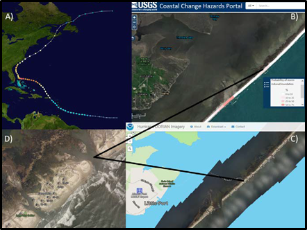
On September 6, 2019, Hurricane Dorian made landfall as a Category 1 storm on Cape Hatteras, North Carolina, roughly 70 miles north of Cape Lookout. The National Park Service (NPS) reported significant damage to NPS infrastructure at the Long Point Cabins in North Core. Post-hurricane NOAA aerial imagery (Figure 1) revealed over 50 island breaches along North Core Banks and severe impacts to the coastal dune ecosystem. South Core Banks endured similar wave and water level conditions, and south-facing Shackelford Banks and Bogue Banks experienced smaller surge and storm waves. The science team will begin collecting data on the changes that occurred to the beach in mid-November. The data set will provide new observations and leverage more than four years of data.
The Ecological Effects of Sea Level Rise Event Response Program, the new NCCOS program supporting the effort, aims to address a major gap in understanding how natural habitats could be used as an alternative to traditional engineering during and after storm events. The program provides immediate assistance for data gathering before, during, and immediately after storms, which are often difficult to anticipate as part of a scientific study.