 An official website of the United States government.
  Official websites use .gov
A .gov website belongs to an official government organization in the United States.
Official websites use .gov
A .gov website belongs to an official government organization in the United States. Secure .gov websites use HTTPS
A lock or https:// means you’ve safely connected to the .gov website. Share sensitive information only on official, secure websites.
Secure .gov websites use HTTPS
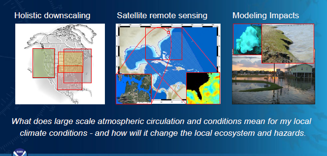
A lock or https:// means you’ve safely connected to the .gov website. Share sensitive information only on official, secure websites.Understanding and predicting climate-related issues along coastlines is important for management and coastal resiliency. We provide scientific information and tools on connections between climate, weather and coastal impacts from hazards including storms, rising seas, floods, and changing air/water temperatures. Satellite remote sensing technology and large-scale weather patterns are used to test and develop coastal change indicators, metrics and models to inform coastal managers on adverse ecological situations affecting vital resources, habitats and people.
Why We Care:
Significant impact and damage to our coastal environments can occur due to changing climate, and increasingly more severe and frequent weather events. These weather – water events and subsequent damage are of great concern for people living in affected coastal communities and the vital ecosystems and resources we protect. We use climatological data obtained nearly simultaneously over a relatively large area of the atmosphere and coastal water bodies from NOAA and other sources to create a framework to assess indicators of predictability of anomalous events damaging our coastal environments.
We determine how climate change driven extremes interact with, or compound existing risks and impacts on coastal ecosystems. We determine how processes can be tracked, how impacts can be predicted and translated into environmental indicators which allow managers to take proactive measures.
What We Are Doing:
We use satellite-derived data, in situ conditions and atmospheric patterns over large geographic areas as inputs to predict changes in coastal ecosystems. Results are analyzed and reassessed to eventually determine what weather-driven indicators can be used to measure or model a particular resilience characteristic. An example is using sea surface temperature (SST) data from large areas collected from satellites. The SST data were used to model weather driven coastal change that can cause sea turtle hypothermia and mortality. Weather patterns have also been used to 1) evaluate satellite chlorophyll a and water clarity patterns in the Great Lakes and South Florida; 2) track kelp distribution, trends and changes in biodiversity patterns in MPAs; and 3) model and predict elevated sea levels and nuisance flood events in Mid- Atlantic and Southeast coastal areas.
- Evaluated linkages of weather patterns and water quality responses in South Florida using a synoptic climatological approach to evaluate algal bloom onset and severity, highlighting the contribution weather factors have on algal blooms. (2012)
- Modeled how regional winds in specific sequences contribute to daily, monthly and seasonal changes in water clarity for the Southeastern U.S. (2014)
- Assessed cold snap mortality and hypothermia in loggerhead and green sea turtles in south Florida coastal ecosystems to develop a biological cold stress index using satellite sea surface temperature and weather pattern forcing. This work allows sea turtle rescue workers to be better prepared for when the next cold snap mortality or hypothermia even may occur. (2015)
- Subsequent South Florida work, defined water clarity patterns in South Florida coastal waters and their linkages to synoptic-scale wind forcing using water clarity as the climate indicator. (2016)
- Developed a non-linear autoregressive model with exogenous input to model climate-water clarity relationships by reconstructing a historical water clarity index for the coastal waters of the Southeastern USA. (2016)
- In a multi-partner effort with the Climate Program Office, COOPS and external partners, used high quality satellite altimetry and in situ data to model relationships between changing weather patterns, storm frequencies and nuisance flood events for NOAA high priority areas including sentinel sites and facilities. This work allows regional-local scale predictions of the probability of nuisance flood events (2019).
- Continue collaborations with external research partners to create models to support outlooks of coastal inundation and flood risk for vulnerable areas within the NC Sentinel Site Cooperative. This work will help guide restoration and adaptive planning in the Sentinel Site Cooperative using machine learning models to better understand the combined effects of ‘upstream’ and ‘downstream’ sources of water level variability associated with changes in inundation that can affect marsh sustainability.
Weather and climate patterns and extremes are undoubtedly linked to coastal effects such as floods, marsh inundation and movement, water quality, hypoxia, water clarity, and species mortality. Integrating downscaled weather data and information is critical to understand climate impacts, predict and forecast future coastal changes so managers and people living in coastal areas can consider measures to enable coastal resiliency.
Benefits of our Work:
This project will identify and link key atmospheric drivers to coastal hazards and impacts through scientific assessments and progressive machine learning techniques. New tools and predictions of hazardous conditions developed in this project improves links to management through implementation of adaptive strategies for measuring and tracking rates and severity of change in systems.
Multiple management benefits include: improved response to increased hazard risk, thereby reducing further degradation of coastal ecosystems; more targeted monitoring of “at-risk” sites and impacted resources in protected areas (e.g. FKNMS, Great Lakes, Beaufort, NC); and improved guidance of cost-effective mitigation strategies for impacted shorelines, habitats and resources. The science solutions and tools from this project will be integrated into existing NOS and academic partner decision-support frameworks including the CO-OPS Coastal Inundation Dashboard, and in Federally protected areas.