 An official website of the United States government.
  Official websites use .gov
A .gov website belongs to an official government organization in the United States.
Official websites use .gov
A .gov website belongs to an official government organization in the United States. Secure .gov websites use HTTPS
A lock or https:// means you’ve safely connected to the .gov website. Share sensitive information only on official, secure websites.
Secure .gov websites use HTTPS
A lock or https:// means you’ve safely connected to the .gov website. Share sensitive information only on official, secure websites.In response to repeated nuisance flooding events that have impacted operations and visitor access at the Battleship NORTH CAROLINA Park, NCCOS scientists are supporting park mangers in their efforts to redesign the park surrounding the historic WWII battleship.
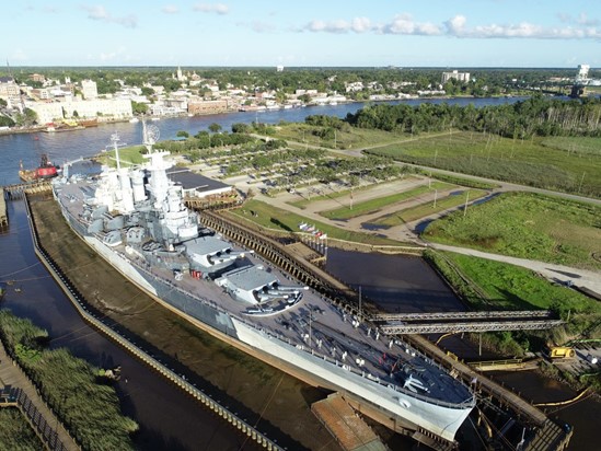
Photo 1. The battleship and the adjacent flood-prone visitor parking lot. In this picture, the battleship is temporally surrounded by a cofferdam for hull refurbishment. Credit: Ryan Giannelli, NOAA NCCOS.
Why We Care
The USS North Carolina, a National Historic Landmark that serves as North Carolina’s official memorial to WWII veterans, is a highly treasured cultural resource and one of the most frequented tourist attractions in the state, with more than 250,000 visitors annually (Photo 1). Since 1961, the USS North Carolina has been moored in a dredged slip on the Cape Fear River among more than 2,000 acres of tidal wetlands and intertidal shoreline on Eagles Island, directly across from Wilmington, North Carolina. The frequency and severity of flooding events along this stretch of the river has increased dramatically, with 50 percent more flooding events in the past 15 years than during the previous 60 years combined. “Sunny day” flooding at Battleship Park results in restricted access to visitors and loss of revenue, vital to maintain the ship and the park’s tourist facilities (Photo 2).
What We Are Doing
The landscape redesign, called “Living With Water,” involves converting two acres of impervious surface to tidal wetland and installing a living shoreline along the battleship’s berth. NCCOS scientists, in addition to advising on living shoreline design, instrumented the site with water-level and salinity sensors and collected Unmanned Aircraft Systems (UAS, aka drone) imagery to facilitate the creation high-resolution elevation models of the project area. These elevation models will be used to support the redesign effort.
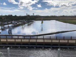
Photo 2. Battleship Park “sunny day” parking lot flooding as viewed from the battleship. Credit: USS North Carolina Battleship Commission.
To date, NCCOS has used the collected data to create a visualization tool that illustrates flooding potential at any given stage of the local tide cycle (see visualization image below).
Benefits of Our Work
Project results are informing design of the restoration work and helping Battleship Park site managers communicate the specific challenges they face.
Once completed, this project will increase wetland habitat along an urbanized stretch of the Cape Fear River and will serve as an outdoor classroom, offering an opportunity to educate visitors about the value of nature-based solutions to coastal hazards and providing a model for responding to the challenges of nuisance flooding events.
Dr. Jenny L. Davis, NCCOS Research Ecologist, leads this project with assistance from scientists Dr. Carolyn Currin (NCCOS) and Quentin Walker (CSS Inc.). The project is in partnership with the Battleship North Carolina.
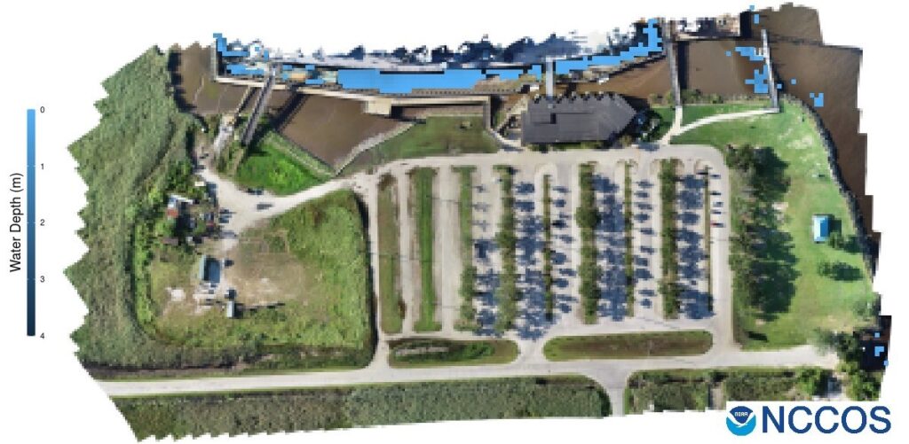
An NCCOS flood visualization tool to support restoration efforts at Battleship Park, North Carolina. View the visualization tool here. Credit: Quentin Walker, CSS Inc.