In 2019, Olympic Coast National Marine Sanctuary (OCNMS) began evaluating the condition of marine resources inside its boundaries. This collaborative project is supporting this process by working closely with local experts to identify key ecological indicators and to define the status and trends for those indicators using existing information. This updated information is critical for OCNMS and will form the scientific basis for its next management plan review starting in 2021.
Why We Care
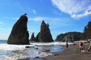
Olympic Coast National Marine Sanctuary (OCNMS) encompasses about 3,189 square miles off the Washington coast, extending from Cape Flattery to the mouth of the Copalis River. This area includes significant living marine resources, including 29 species of marine mammals (whales, dolphins, porpoises and sea otters), large populations of nesting seabirds, and some of the last remaining wilderness coastline in the lower 48 states. The sanctuary also helps protect cultural and maritime heritage resources, including shipwrecks and cultural artifacts from Washington’s Coastal Treaty Tribes. The presence of these natural, historic and cultural resources attract tourists and boost the local economy, supporting over 1,000 jobs and generating $46 million in revenue for businesses and the nearby community.
Communities along the Washington coast consequently depend on the sanctuary to safeguard these valuable marine resources. Effective protection requires that the sanctuary periodically evaluate the condition of living marine resources and habitats, and understand the trends associated with them over time. This updated understanding is critical because it allows the sanctuary managers to identify and address new and emerging threats to these resources. It has been over a decade since the last condition report was compiled for OCNMS. Since then, the Olympic Coast region has experienced considerable and widespread ecosystem change. To better understand and respond to these changes, the Sanctuary is developing an updated condition report. Condition reports provide a summary of sanctuary marine resources and habitats, key pressures on those resources, their current condition and trends, their role in providing ecosystem services valuable to communities, and management responses to address pressures that may threaten the integrity of the marine environment. Condition reports are a tool to determine if the Sanctuary is achieving its resource protection and improvement goals, and to revise its goals and management strategies accordingly in partnership with its stakeholders.
What We Did
Ecological indicators are biological, chemical, physical measurements that serve as proxies for ecosystem condition and can be used to track changes over time. This project is supporting OCNMS’s condition reporting process by working with local experts to: (1) identify ecological condition indicators relevant to OCNMS and (2) synthesize information describing the status (good, fair, poor, unknown) and trends (increasing, decreasing, no change, unknown) for these indicators inside of OCNMS. These status and trends rankings will also be assigned confidence levels based on the strength of the evidence and level of agreement among participants. No new datasets will be collected or synthesized during this project. This updated information will be critical for OCNMS to identify new threats to resources and develop targeted management strategies moving forward.
In 2018 to 2019, an initial list of ecological indicators was developed by leveraging and building on work of several previous, regional indicator efforts including the State of Washington, Channel Islands National Marine Sanctuary (CINMS), Monterey Bay National Marine Sanctuary (MBNMS) and California Current Integrated Ecosystem Assessment (CCIEA) among others. This initial list of indicators was vetted and refined during on-site meetings with local experts in May 2019, including from Washington’s Coastal Treaty Tribes, NOAA’s Northwest Fisheries Science Center, the State of Washington, Washington Sea Grant, University of Washington and NOAA’s Pacific Environmental Marine Laboratory. Existing, readily-available information for tracking the status and trends of these indicators were identified at this workshop.
In 2019 to 2020, NCCOS built on the results from this expert workshop and compiled readily-available information describing the status and trends for key indicators. This status and trends information was reviewed and discussed by local experts during a workshop in January 2020, and was used to describe the overall condition of resources within OCNMS. NCCOS compiled these expert-defined status and trends in a draft document, which was provided to OCNMS. This draft material make up the core content for the ecological questions in OCNMS’s updated report.
Benefits of Our Work
OCNMS’s updated condition report will be used directly to inform its updated management plan starting in FY2021, which will guide the conservation and management of OCNMS for the next decade.