We are using a coupled groundwater–surface water modeling system to evaluate the site-specific performance of proposed shoreline adaptation actions with sea level rise and storms. This will inform the design and implementation of flood mitigation strategies that enhance coastal resilience.
Why We Care
Coastal flooding associated with sea level rise and more intense storm events poses a serious risk to California communities and the infrastructure on which they rely. As communities and other coastal stakeholders nationwide engage in adaptation planning to mitigate the impacts of flooding, developing site-specific modeling is critical for evaluating the efficacy of proposed projects and policies to improve outcomes for residents and the built and natural environments.
What We Are Doing
This project will implement a mature, coupled groundwater–surface water modeling system developed previously by the project team to evaluate the performance of proposed shoreline adaptation actions and to inform the design and implementation of flood mitigation strategies that enhance coastal resilience.
The modeling framework used for the proposed work couples a high-resolution coastal hydrodynamic model, a dynamic groundwater flow model, and a geospatial impacts assessment module to evaluate the flood risk reduction and non-protective benefits of shoreline adaptation strategies. The framework will be applied to test nature-based, conventional, and hybrid mitigation strategies across a range of sea level rise and storm scenarios. Given the high resolution and broad coverage of the models, the framework can be applied within a single community or across a planning corridor to capture interactions between multiple standalone or phased projects along neighboring or proximate shorelines. This allows for the assessment of the cumulative impacts of proposed projects on regional flood exposure.
Modeling scenarios and outputs will be co-developed with project partners to ensure their usefulness and relevance to supporting applications for flood mitigation funding or other assistance. Input from coastal decision makers stakeholders from partner communities will be gathered through all phases of the work.
Benefits of Our Work
Project outputs will provide coastal managers and other partners with locally relevant guidance on the hydrologic, socioeconomic, and ecological implications of sea level rise and the degree to which proposed management solutions achieve priorities related to resiliency. The outputs will be co-developed with community partners to support applications for federal funding to design and implement flood mitigation or restoration activities. Specific outputs will include:
-
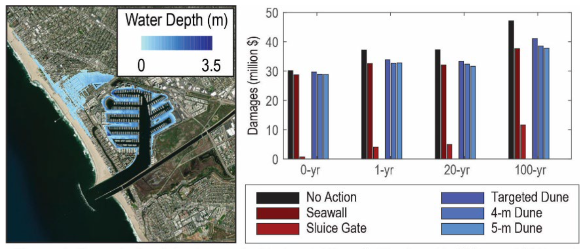
- Maps of inundation area and depth across a range of sea level rise scenarios and storm return intervals for the no-action scenario and the nature-based, conventional, and hybrid adaptation scenarios identified with stakeholders.
- Graphical comparisons of the performance of each adaptation scenario with respect to economic, social, and ecological criteria.
- A cost-benefit analysis of the modeled scenarios using guidance from the grant agency or program that the project partner is targeting for support.
- An interactive web tool for project partners and the public to view the model outputs and compare them across alternatives to guide the next steps for their coastline.
This project is led by Dr. Michelle Hummel at University of Texas at Arlington, in collaboration with Dr. Kevin Befus at University of Arkansas, and funded by the NCCOS Effects of Sea Level Rise (ESLR) Program.