We are investigating the coastal processes and hazards that damage roadway pavement. This work combines hydrodynamic, groundwater, and pavement models, along with an adaptation impact assessment, to understand overtopping and pavement moisture. We will develop a toolkit for decision makers to assess the vulnerability of roadways to sea level rise and flooding. We will also evaluate the effectiveness of natural and nature-based features to protect and increase the longevity of roadway infrastructure.
Why We Care
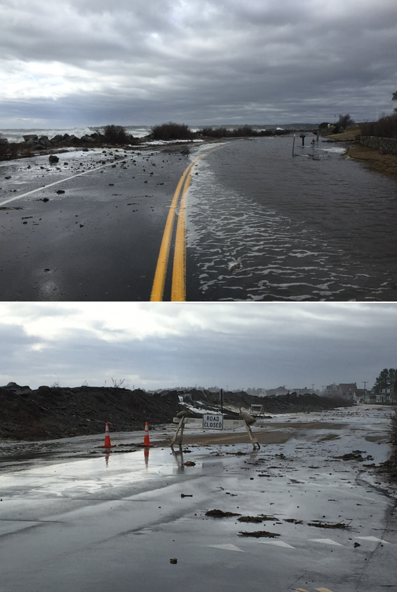
Coastal communities rely almost exclusively on their road networks for transportation of people, goods, and services, making the integrity of these networks key to community resilience in the face of sea level rise.
Sea level rise can lead to greater incidents, volumes, and durations of flooding; rising groundwater; storm surges; and wave action, all of which threaten coastal roadways. Both gradual changes and extreme events deteriorate pavement over time, triggering pavement failures that require reconstruction to restore serviceability.
Engineers have investigated these impacts individually, but a comprehensive approach is needed that combines the effects of different mechanisms on the overall deterioration of the pavement structure. Also, previous transportation infrastructure sea level rise vulnerability studies have primarily used regional-scale modeling, which lacks the resolution needed to adequately evaluate roadways and adaptation options such as adding natural or nature-based features (NNBF).
What We Are Doing
The primary science objectives of this research are to understand the linkages between coastal hazards and pavement damage and to identify the coastal processes that cause pavement deterioration. An additional objective is to evaluate adaptation alternatives, specifically those incorporating NNBF, that will dampen damaging coastal processes to mitigate pavement damage and deterioration.
The primary management objective is to work with end users to prioritize and disseminate data needs and decision support tools, and to establish new transportation agency policies and practices that reduce sea level rise impacts to coastal transportation performance and simultaneously restore or enhance ecosystems.
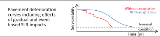
The project team will focus on two geographically and geologically diverse coastal regions of the U.S.: New England (New Hampshire), and the Gulf Coast (Alabama). The team will develop generalized damage functions for pavements subject to the impacts of sea level rise and use them as the basis for pavement deterioration curves (Figure 1). Following pavement evaluation, the team will assess the economic, environmental, and social impacts related to pavement deterioration.
The primary project output will be a toolkit for road planners and decision makers to identify effective adaptation alternatives for coastal roadways to increase their sea level rise resilience. The toolkit will evaluate different scenarios and adaptation alternatives that reduce the magnitude and intensity of sea level rise forcings (e.g., various NNBF).
Benefits of Our Work
Partnerships across agencies and the project team are critical for the project products to change state transportation agency coastal resilience practices to reduce coastal roadway vulnerability. The project team will identify and build relationships with key stakeholders, facilitate stakeholder input, and conduct end user engagement. Two advisory groups will be established. The Management Transition Advisory Group (MTAG) will be a small group whose members represent national interests and policies. The Stakeholder Advisory Group (SAG) will include members at state or local agencies who will partner with the project team on the place-based studies and facilitate agency adoption of project outputs. Beyond the MTAG and SAG, engagement and feedback from a broader community of transportation practitioners will occur via annual webinar or virtual workshops.
The project is led by Professor Jo Sias (University of New Hampshire) with a multi-disciplinary team of co-investigators: Dr. Eshan Dave and Dr. Jennifer Jacobs of the University of New Hampshire; Dr. Bret Webb of the University of South Alabama; Julie LaBranche, Timothy Roache, and David Walker of the Rockingham (NH) Planning Commission; Dr. Jayne Knott of JFK Environmental Services LLC (Upton, MA); and Dr. Scott Douglass of South Coast Engineers, Inc. (Fairhope, AL).
The project is part of NCCOS’s Effects of Sea Level Rise Program (ESLR) Program.