The California Coastal Resilience Network hosted a webinar highlighting research on intermittently open estuaries in California, work funded by NCCOS’s Effects of Sea Level Rise Program.
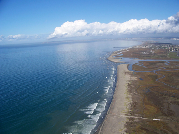
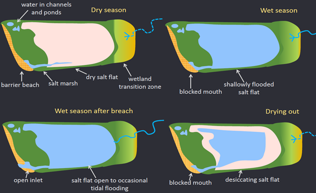
Historically, approximately 98 percent of tidal wetlands in Southern California were intermittently open to tidal action. The diverse and seasonally varying habitats provided by intermittently open estuaries benefit many species. However, very few estuaries in Southern California still exhibit natural cycles of intermittency, and many are managed as permanently open systems, either through construction of jetties, or through dredging.
The conversion from intermittently to permanently open has reduced habitat diversity in the region, making conditions less hospitable for fish species such as tidewater gobies and juvenile steelhead. Permanently open systems also affect sediment accretion, making it harder for marsh elevation to keep up with sea level. Local marshes host a number of endangered and threatened plant and animal species.
The NOAA-funded project provided information to rethink management of these systems and better understand the consequences of different management scenarios.
The researchers studied how Southern California estuaries are affected by sea level rise and how and where nature-based solutions could provide needed resilience. They did this by integrating existing sea level rise and habitat evolution models to understand how physical and habitat changes will occur with rising tides and associated storm events. They also identified estuarine-upland transition zones across Southern California where marsh migration may occur with sea level rise.
The study built on the Southern California Wetlands Recovery Project’s existing collaborative structure, which includes the state’s leading wetland scientists, high-level staff from 18 partner state and federal agencies, and key practitioners conducting on-the-ground restoration in Southern California.
Partners on this California State Coastal Conservancy (South Coast Region)–led project include NCCOS; Point Blue Conservation Science; the University of California, Davis; the U.S. Geological Survey; San Francisco Estuary Institute; and Environmental Science Associates.
To view past webinars from the California Coastal Resilience Network, click here, or join the network here to learn about future webinars.
Additional Resources:
- Southern California Wetlands Recovery Project’s Wetlands on the Edge, Regional Strategy 2018
- Marshes on the Margins: Developing Tidal Wetlands Adaptation Strategies in Southern California
- Refining Ecosystem Model Inputs for Sea Level Rise Vulnerability in the San Francisco Bay Estuary
- Scwrp.databasin.org, also called the Marsh Adaptation Planning Tool (MAPT), includes maps of current and future areas available for marsh-upland transition zones and marsh migration zones, historic habitats, current habitats, and developed lands not currently available for restoration.
- Ourcoastourfuture.org integrates hydrodynamic modeling from CoSMoS scenarios run for three case study sites (Goleta Slough, Los Peñasquitos Lagoon, Tijuana River Estuary), including flooding, wave heights, and current velocities for open and closed inlet conditions. More details are available here.


