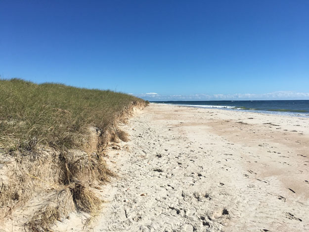
Barrier islands and sand dunes have long been recognized as critical ecosystems that protect coastal areas from storms, while being home to many unique plants and animals. A team of NOAA-funded scientists from Oregon State University and the University of North Carolina is developing the Coastal Recovery from Storms Tool (CReST) for coastal North Carolina, a modeling tool that will predict how barrier islands and sand dunes function and recover following storms. The goal of the project is to enable coastal managers to better evaluate how these natural and managed islands recover from storms and change through time under different sea level rise and management scenarios.
The project team—led by Peter Ruggiero, Laura Moore, and Sally Hacker—is conducting extensive field measurements of topography and vegetation along Cape Lookout National Seashore and Bogue Banks, which includes the town of Atlantic Beach. During their initial field work in October 2016, the team found many impacts from Hurricane Matthew, including dune scarping, exposed historic marsh peat, and even newly deposited sand in some locations. An upcoming expedition in October 2017 will allow the team to examine any recovery from Matthew, as well as other changes that may have occurred. By comparing changes between managed and natural barrier islands, the team hopes to better inform how coastal communities can maximize the ecological and societal benefits of barrier islands and dunes.
“Hurricane Sandy affected such a large portion of the east coast of the U.S., and at the community level people really began to recognize that areas that were fronted by a coastal dune fared much better than areas that were lacking a dune,” observes project co-lead, Dr. Laura Moore. “As we go into the future, it’s my hope that we can find ways to balance the desire to live and vacation at the coast with the natural processes that need to take place in order for barrier islands to persist in the long term.”
For more on this research, supported by NOAA’s Ecological Effects of Sea Level Rise (EESLR) Program through August 2019, watch the project overview video below:
NOAA has committed to provide coastal managers with the information and tools needed to create more storm-proof and resilient coastal communities. NOAA’s EESLR Program provides a suite of products that inform coastal managers on local coastal vulnerably to sea level rise and strategies to mitigate coastal flood risks associated with storm surge and nuisance flooding. The program emphasizes understanding how natural features can provide coastal protection in the future, especially during natural disasters that create high water events, when the value of natural features like sand dunes and barrier islands is most obvious.
For more information, contact David.Kidwell@noaa.gov.