NOAA’s National Centers for Coastal Ocean Science (NCCOS), NOAA’s National Marine Fisheries Service (NMFS), U. S. Geological Survey (USGS) and the RESTORE Council have released the second of seven reports that presents the results of a compilation of existing water quality, habitat monitoring and mapping assessments in the Gulf of Mexico.
Approved as a Gulf-wide investment in 2015, the Council Monitoring and Assessment Program (CMAP) was developed and administered jointly by NOAA and USGS. CMAP, in collaboration with Gulf States, Federal and local partners, academia, non-governmental organizations, and industry, will integrate existing monitoring program information to establish a Gulf of Mexico-wide monitoring network, to support the Gulf Coast Ecosystem Restoration Council in making science-based decisions and evaluating restoration effectiveness.
The report titled Compilation of Existing Habitat and Water Quality Monitoring, and Mapping Assessments for the Gulf of Mexico Region was developed for the RESTORE Council and focused on developing a catalog of descriptive summary information for existing assessments of habitat and water quality monitoring, and mapping products. This catalog will be integrated with the searchable inventory database webtool developed for this project, detailed in the first report in this series, which will enable users to explore data that can be used to inform restoration actions based on the best available science.
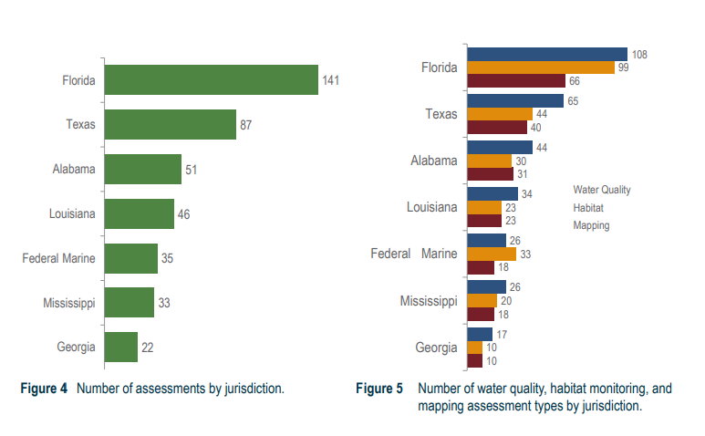
A total of 274 monitoring and mapping assessments are summarized in the catalog. The majority (213, or 77%) monitor water quality, 177 (65%) monitor habitats, and 133 (49%) include assessments with a mapping component.
For more information contact Randy.Clark@noaa.gov or see the NOAA project website.