As sea levels continue to rise, so too does nuisance flooding along the coast, which can cause road closures, damage to infrastructure, and increased insurance costs.
Using Coos Bay, Oregon, as a study area, NCCOS-funded researchers found that restoring wetland habitat is one way to reduce future flooding in the region’s downtown areas and along its major transportation routes. These natural areas help buffer infrastructure from extreme tides and rising sea levels by allowing floodwaters to spread across restored marshes instead of overtopping levees
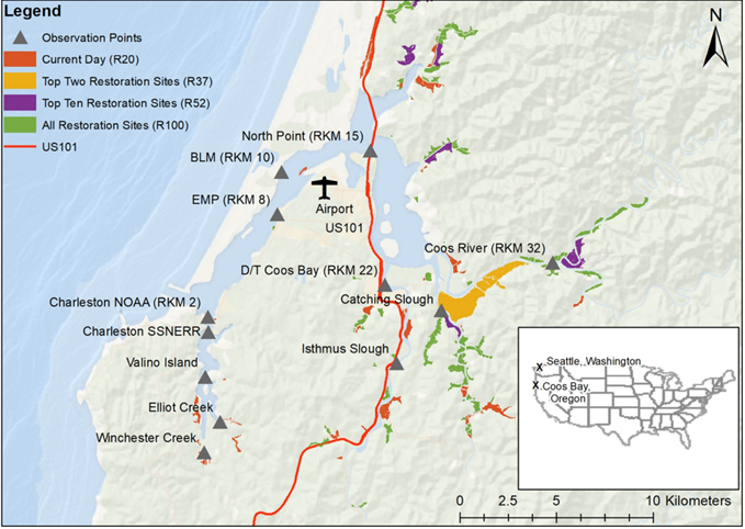
The research team developed a hydrodynamic model to predict changes in estuarine conditions and rapidly assess different restoration scenarios. Their analysis included repositioning levees to restore wetland habitat, effectively creating a larger “bathtub” for floodwaters.
Under a scenario with no additional restoration, model projections indicate that by 2100, the highest high tides each month (known as spring tides) could flood large portions of downtown Coos Bay, with more than 11 inches of water across both lanes of U.S. Highway 101 (Figure 2a). The northbound lanes could experience over 19 inches of water across a 2,300-foot stretch of road, making the route impassable. When the team evaluated this flood scenario with a full restoration of the marshes (Figure 1), the extent of the flooding would be less severe and the southbound lane of U.S. 101 would be fully protected (Figure 2b).
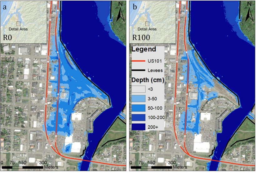
Study findings show that wetland restoration is more effective at reducing tidal flooding at inland sites, with less flood reduction near the coast. The researchers also found that restoration effectiveness was driven by increased flood accommodation space, allowing floodwaters to spread and not overtop levees near communities.
The team aims to develop practical tools and insights for regional restoration efforts, such as the Columbia Estuary Ecosystem Restoration Program (CEERP), a joint initiative of the Bonneville Power Administration, the U.S. Army Corps of Engineers (Portland District), and others. To date, these partners have successfully completed numerous large-scale levee realignment projects.
The project is led by Oregon State University’s Department of Fish and Wildlife and is funded through the NCCOS Ecological Effects of Sea Level Rise Program, and authorized by Congress in Public Law 102-567, section 201 to provide scientific information to better conserve and manage marine living resources. This work supports the Coastal Zone Management Act sections 1451 and 1452. Project partners include Louisiana State University, the Institute for Applied Ecology, the U.S. Department of Energy’s Pacific Northwest National Laboratory, the University of Oregon’s Institute of Ecology and Evolution and Department of Earth Sciences, and the Bonneville Power Administration. The Partnership for Coastal Watersheds provided local expertise to develop the restoration scenarios and refine flood predictions.