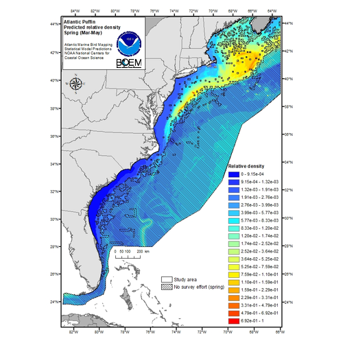
Seabirds and other marine birds are wide-ranging and highly mobile so mapping their at-sea distributions presents a significant challenge. The purpose of this project was to produce high-resolution predictive maps of marine bird relative density within U.S. Atlantic Outer Continental Shelf (OCS) waters. These maps will help guide placement of offshore renewable energy facilities to reduce potential impacts on birds and will fill an important spatial planning information gap in the region.

Why We Care
In May 2011, NOAA and the Department of the Interior’s Bureau of Ocean Energy Management (BOEM) entered into a Memorandum of Understanding (MOU) on “Coordination and Collaboration Regarding Outer Continental Shelf Energy Development and Environmental Stewardship.” Under this MOU, NOAA and BOEM identified several key areas of cooperation including “Identifying and undertaking critical environmental studies and analyses, including the sharing of information, and making specific scientific efforts to significantly improve products and demonstrate efficient governance and sound stewardship of the Nation’s marine ecosystems, resources, and coastal communities,” and “Collaborating on scientific, environmental, and technical issues related to the development and deployment of environmentally sound and sustainable offshore wind and marine and hydrokinetic (MHK) renewable energy technologies.”
An understanding of marine bird distribution and abundance is important to environmentally responsible development of offshore renewable energy resources such as wind farms. Spatial information about marine birds can help to reduce potential conflicts between offshore activities and important bird areas. High-quality, high-resolution maps of marine bird occurrence and abundance are a key information gap for spatial planning and environmental assessment in the Atlantic OCS region. Therefore, NCCOS worked with the BOEM Environmental Studies Program, the U.S. Geological Survey (USGS) Patuxent Wildlife Research Center, and the U.S. Fish and Wildlife Service (USFWS) Division of Migratory Bird Management to fill this gap by developing seasonal and annual maps of marine bird occurrence and relative density.
What We Did
We developed high-spatial resolution statistical model predictions of the long-term average spatial distributions of marine bird species in U.S. Atlantic OCS waters and produced map products that support regional planning efforts.
This project had four main components:
1. In collaboration with USGS and USFWS, we derived an effort-standardized survey dataset from the Northwest Atlantic Seabird Catalog database (previously referred to as the ‘Compendium of Avian Occurrence Information for the Continental Shelf waters along the Atlantic Coast of the U.S.’). The survey dataset represents over three decades of science-quality, geographically referenced, visual sighting data from boat-based and aerial surveys conducted in U.S. Atlantic OCS waters by a range of entities including government agencies, non-governmental organizations, and academic researchers. These data were combined with additional survey data from the Canadian Wildlife Service, Environment and Climate Change Canada.
2. We compiled a consistent, unified set of environmental spatial data layers for U.S. Atlantic OCS waters including oceanographic, atmospheric, physiographic, and other relevant variables from remote sensing, long-term observational databases, data-assimilating ocean models, and other sources.
3. We conducted spatial predictive modeling that related the occurrence and abundance of marine birds in the survey data to the environmental spatial data layers and used those relationships to predict the long-term relative density of each species throughout U.S. Atlantic OCS waters along with estimates of the statistical uncertainty in the predictions.
4. We provided a summary report and synthetic map products that support incorporation of avian spatial distributions into regional planning efforts. The format of the map products takes into account management-specific needs, in communication with BOEM, regional ocean councils, and other relevant management and policy authorities.
What We Found
Results of this project include seasonal and annual predictive maps of relative density for 47 marine bird species in U.S. Atlantic OCS waters.
Benefits of Our Work
The predictive maps of marine bird relative density are being used by BOEM, other federal and state agencies, non-governmental organizations, and regional ocean councils to aid sound environmental stewardship, renewable energy siting, and other spatial planning needs in Atlantic OCS waters.
