We compiled observations of deep-sea corals and chemosynthetic communities from field surveys and developed spatial predictive models for these organisms and habitats in the U.S. Gulf of Mexico. Maps and geospatial data depicting the observed and predicted distributions of these organisms and habitats can be used to inform environmental risk assessments, environmental impact statements, and other decision-support documents related to the review of proposed offshore energy development in the region.
Why We Care
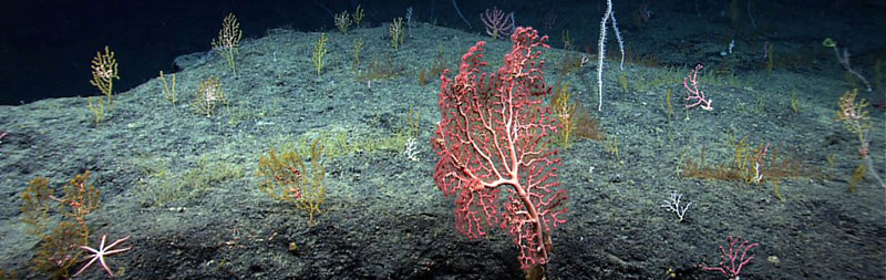
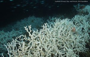
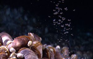
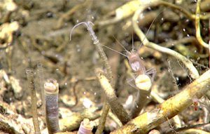
Deep-sea corals, also known as cold-water corals or deepwater corals, can create local hotspots of biodiversity by providing three-dimensional structure that increases the complexity of habitats available for use by other organisms, such as fishes and echinoderms. They are generally long-lived, slow-growing, and fragile, making them vulnerable to human impacts. Similar to deep-sea corals, habitats created by chemosynthetic fauna at cold seeps (i.e., locations where fluids containing reduced chemicals like methane and sulfide emerge from beneath the seafloor) may increase habitat heterogeneity.
The Bureau of Ocean Energy Management (BOEM) manages the development of energy and mineral resources in the U.S. Gulf of Mexico in an environmentally and economically responsible way across the approximately 160 million acres (approximately 650,000 km2) of the Gulf of Mexico Outer Continental Shelf (OCS) region. Offshore energy projects often include activities that may physically disturb the seafloor and could negatively affect benthic biota. BOEM has identified deep-sea corals and chemosynthetic communities as sensitive deep-water biota and included requirements in their Notices to Lessees (NTL No. 2009-G40) for oil and gas operators to avoid such habitats in the Gulf of Mexico. Having the most comprehensive and up-to-date information on the spatial distributions of deep-sea corals and chemosynthetic communities is essential for BOEM to assess the potential impacts of offshore energy development on the marine environment in the Gulf.
What We Did
This study had three main components:
- We compiled a database of presence-absence observations of deep-sea corals and chemosynthetic communities with associated measures of sampling effort (i.e., the area associated with each sample) from 22 data sets containing segments of video or still images from field surveys conducted using underwater vehicles between 1988 and 2018.
- We identified and assembled spatially-explicit data layers depicting depth and seafloor topography, seafloor substrate, oceanography, and geography to use as environmental predictors.
- We developed spatial predictive models that related the occurrence of deep-sea corals and chemosynthetic communities to the spatial environmental predictors. We used these models to produce maps of the predicted spatial distributions of 44 deep-sea coral taxa and three chemosynthetic communities and maps of the predicted taxonomic richness for several groups of deep-sea corals.
We prepared a technical report that summarizes the findings of the study and a digital data package containing the database of observations of deep-sea corals and chemosynthetic communities and geospatial data layers depicting the model predictions and the environmental predictors used in the models. This data package will be publicly available for download via NOAA’s National Centers for Environmental Information (NCEI).
Benefits of Our Work
The maps and data products developed for this study will be used by BOEM to inform and support environmental risk assessments, environmental impact statements, and other decision-support documents related to the review of proposed offshore energy development in the region. The maps and data products can also be used to inform other regional ocean planning and management decisions for proposed activities that could impact these sensitive benthic biota and to guide future ocean exploration in the Gulf of Mexico.
Caption for large photo at top of page: “Diverse deep-sea coral community on the Florida Escarpment.” Credit: NOAA Office of Ocean Exploration and Research.