In 2012, the US Naval Facilities Engineering Command (NAVFAC) Marianas developed an Integrated Natural Resource Management Plan (INRMP) for the Joint Region Marianas (JRM). The purpose of this plan is to mitigate impacts of the US Navy’s mission on submerged lands under their control and develop functioning, sustainable ecological communities. Local staff from NAVFAC Marianas requested that NCCOS develop an updated habitat map for the Haputo Ecological Reserve Area, Guam to help inform their resource decisions and execute plan recommendations.
Why We Care
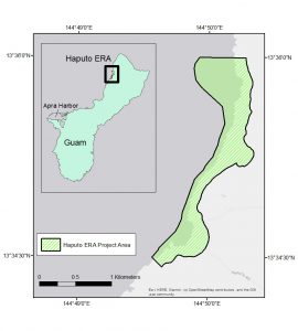
The Haputo Ecological Reserve Area (ERA) is located on the northwest coast of Guam, roughly 15 miles northeast from Apra Harbor and the Guam Naval Base (Figure 1). The ERA was designated in 1984 and covers roughly 1.25 km2 of limestone forest, sandy beach, coral reef, and known archeological sites. In addition to being a cultural heritage site, the reserve provides an important ecosystem for the Guam coast because it has remained mostly undeveloped, and can be seen as a baseline for comparing other nearshore habitats for both submerged and exposed environments.
What We Will Do
The goal of this project is to produce marine, estuarine and terrestrial habitat maps in Haputo ERA, Guam to better support the ecosystem sustainability goals of the INRMP in the JRM. These maps will depict the distribution of key biological and geomorphological habitats within the ERA, tailored to meet NAVFAC’s informational needs and the coastal and marine ecological classification standard (CMECs). They will be developed using existing, readily available remote-sensing data, including multispectral satellite imagery and Light Detection and Ranging (LiDAR) data (and potentially small Unmanned Aircraft Systems (sUAS) data). Underwater georeferenced videos and photos will also be collected as ‘ground-truth’ information to inform habitat map development of field observation habitat data points and evaluate the performance and accuracy of habitat models. The final deliverables will include Geographic Information Systems (GIS) habitat maps, underwater videos, an online web map, and a final report describing the methods used for map development. These data and the final report will be made publicly available for download and online-viewing at the end of the project (see Data Collections below).
Benefits of Our Work
The habitat products developed during this project will provide a critical spatial framework to mitigate potential impacts of the U.S. Navy’s mission and determine an ecosystem baseline within the Haputo ERA. Future projects or management actions in these lands will benefit greatly from the updated imagery, habitat map products, and underwater photos and videos compiled during this project. These data sets will inform decisions about mission training activities, resource monitoring, protected species, land-based sources of pollution and scientific research moving forward. This project and resulting products will also help support other marine management efforts by the Guam territorial government and other local federal agencies.
This work was funded by NAVFAC Marianas and will be conducted in partnership with NAVFAC, Guam territorial government, NOAA National Marine Fisheries Services, NOAA Office of Coastal Management and the University of Guam.