NCCOS has evaluated the use of underwater gliders to improve Gulf of Mexico hypoxic zone, also known as the dead zone, monitoring. This effort resulted in the development of a comprehensive plan for integrating glider capabilities into Gulf of Mexico hypoxic zone monitoring efforts.
The northern portion of the Gulf of Mexico experiences an annual summer hypoxia event when over-enrichment of nutrients in the water combined with summertime stratification of the water column results in very low levels of bottom water dissolved oxygen. Ships have monitored this hypoxic zone since 1985, and despite decades of research, fully coupled hydrodynamic water quality models cannot accurately forecast the hypoxic zone. The use of innovative monitoring technologies—such as autonomous underwater gliders—contributes data to enhance models, identify the extent of the hypoxic zone (dead zone), and validate data collected during survey cruises.
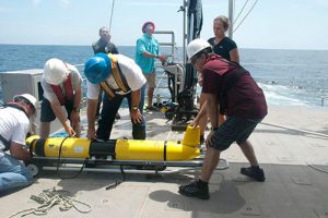
During the 2014 hypoxia season, NCCOS and the U.S. Integrated Ocean Observing System demonstrated how gliders deployed from July to September monitor hypoxia in the northern Gulf of Mexico. The scientists successfully operated two gliders in the Gulf of Mexico dead zone during the testing period. During the same period, Dr. Steven DiMarco of the Texas A&M University Geochemical and Environmental Research Group (GERG) led a research cruise that took shipboard hypoxia measurements. The coordinated mission enabled efficient and effective comparisons between the glider- and ship-collected data in a highly stratified, shallow, and heavily ship-trafficked region of the northern Gulf of Mexico.
Following the successful 2014 demonstration, NCCOS sponsored a pilot study in 2016 and 2017 to further expanded and tested the application of gliders toward improving Gulf of Mexico hypoxic zone monitoring. The goal was to contribute to the development of a robust, comprehensive, and sustainable (operational) 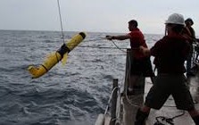 monitoring program.
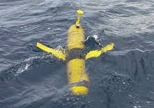
The 2016-2017 ocean glider summer field campaigns demonstrated their capability and operational robustness to obtain dissolved oxygen data as a comprehensive approach to hypoxic zone monitoring. The project evaluated the effectiveness of gliders for routine hypoxic zone characterization in terms of efficiency (time, cost), accuracy, resolution, breadth (e.g., closeness to bottom, areal and volumetric expanse), telemetric capabilities (e.g., near real-time), and sensor response time.
The project developed a revised scalable glider monitoring implementation plan (2018) for the hypoxic zone for transitioning glider applications to operations. Among the key findings found in the report:
- One-two gliders simultaneously in water is not sufficient enough to create a map of region due to speed (around 0.5 nautical mph) and current (strong eastward current preventing movement onshore or offshore)
- Density gradients are a limiting factor
- Explore use of Autonomous Surface Vehicles
- Buoyancy Gliders CAN: Reliably sample within 2 m of bottom (if environmental conditions allow)
- Buoyancy Gliders CANNOT: Reliably map the coastal environment (due to slow forward speed and challenges in navigating in shallow, highly stratified, strong and variable coastal current conditions)
- RECOMMENDATION: Adopt a hybrid approach that uses combination of buoyancy gliders and autonomous vehicles.
The glider-hypoxia demonstration project credits the efforts of many organizations cooperating, collaborating, and showing glider efficiencies (and deficiencies) for detecting and assessing hypoxia.
For more information, contact David Hilmer.