Marshes with a small difference between low and high tides (<2m) require adjusting aerial (lidar) derived elevation to account for vegetation height. NCCOS supported scientists from Oregon State University and the U.S. Geological Survey offer a novel approach for correcting lidar elevation data to account for vegetation height that aims to minimize the on site data collection required to ensure accuracy.
The plants and animals that occupy a marsh and the health and persistence of the marsh are heavily driven by the elevation of the marsh surface and how much and for how long the marsh is inundated with water (tidal range) each day. For this reason, being able to predict the future marsh conditions, relies heavily on having accurate surface elevation data.
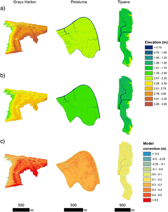
Marsh elevations have often been determined from DEMs (digital elevation models) that are derived from lidar (Light Detection and Ranging) that is obtained from aerial flights, and does not require actually entering the marsh.Though the remote sensing approach is much easier to cover large areas, it often overestimates elevation by 10-40 cm due to vegetation height. It is well known that field based satellite positioning called real time kinematic (RTK)-GPS surveys, greatly improve this elevation error, however it requires a huge effort of walking through the marshes. The team set out to determine if there could be a reliable method for adjusting lidar derived elevation data with limited field work that maintains spatial resolution.
The study team developed a statistical model of lidar error for 17 tidal marsh sites along the Pacific coast. They applied the models and compared them to field data (RTK-GPS) to assess accuracy, and compared the performance of their model approach against other commonly applied adjustment techniques. The team also evaluated the minimum density of field collected (RTK-GPS) data points that were necessary to achieve maximum accuracy, to identify the ideal balance between effort and data quality. .
The study describes a new approach called the Lidar Elevation Adjustment with NDVI (LEAN) tool to correct DEM error in marshes. The study showed that the marsh DEMs could be corrected for vegetation, creating an elevation map with greater accuracy, while still maintaining a high resolution. Researchers used LEAN to correct the DEMs with vegetation indices from multispectral airborne imagery (NAIP) and field real time kinematic (RTK)-GPS surveys. USGS scientists recently released the high resolution DEM for marshes and coastal areas across San Francisco Bay. The LEAN approach has also been applied to marshes in the Chesapeake Bay. Corrected marsh elevation map will substantially assist researchers and coastal managers to identify mitigation options, areas vulnerable to sea level rise, and inform restoration activities.
The research project described in the paper was supported by the NCCOS Ecological Effects of Sea Level Rise Program (EESLR) titled “ Refining Ecosystem Model Input for Sea Level Rise Vulnerability in the San Francisco Bay Estuary.”