Home > Explore News > Sea Level Rise Model Provides Real-Time Guidance on Tropical Storm Gordon

Sea Level Rise Model Provides Real-Time Guidance on Tropical Storm Gordon

Published on: 09/06/2018
Primary Contact(s): david.kidwell@noaa.gov

Predicted Tropical Storm Gordon maximum wave heights above North American Vertical Datum of 1988 (NAVD 88) for the LA-MS-AL coastlines issued 4 September 2018. Credit: Louisiana State University Center for Computation & Technology.

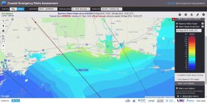
As Tropical Storm Gordon headed for the Mississippi and Alabama coastlines, a version of the NCCOS-sponsored Northern Gulf of Mexico ADCIRC+SWAN model ran in real-time providing storm surge and wave guidance for disaster response agencies.

Model results are displayed on the Coastal Emergency Risks Assessment (CERA) website at the Louisiana State University Center for Computation & Technology (viewing model runs requires a login).

The coupled Northern Gulf of Mexico ADCIRC+SWAN model (ADvanced CIRCulation and Simulating WAves Nearshore) is a product of the NCCOS EESLR project in the Northern Gulf of Mexico. Optimization and transition of the model for operational forecasts was funded, in part, by the Department of Homeland Security’s Coastal Resilience Center of Excellence. .

For more information, contact Dave.Kidwell@noaa.gov,

Explore Similar News

About NCCOS

NCCOS delivers ecosystem science solutions for stewardship of the nation’s ocean and coastal resources to sustain thriving coastal communities and economies.

Stay Connected

Sign up for our quarterly newsletter or view our archives.

NCCOS Multimedia

Visit our new NCCOS Multimedia Gallery. 

Follow us on Social

Listen to our Podcast

Check out our new podcast "Coastal Conversations"