Coastal Conversations Podcast: Episode 3
Poplar Island, a once thriving island of 1,100 acres in the Chesapeake Bay, had been reduced to about four acres by the 1990’s. Through a partnership with the Army Corps of Engineers, and the Maryland Department of Transportation, Maryland Port Administration, scientists have been working to restore habitat on the island using dredged sediment, which in turns keeps the shipping channels open for large ships entering ports. NCCOS scientists are tracking fish to see how they move through the waters of the restored island. Listen to NCCOS scientist, Dr. Matt Kendall, explain the technology they use to investigate how fish use this restored habitat. Learn more about this ongoing project.
Listen here:
Episode Transcript:
Poplar Island was once a thriving community in the Maryland portion of Chesapeake Bay. Since a survey measured the island at over 1,110 acres in 1847, the combined forces of erosion, sea level rise, and subsidence reduced the area to small islets totaling only four acres by 1990. Federal and state partners from the U.S. Army Corps of Engineers and Maryland Department of Transportation, Maryland Port Administration have jointly sponsored a project to restore this lost, remote island habitat. Officially called the Paul S. Sarbanes Ecosystem Restoration Project at Poplar Island, the project relies on beneficial use of dredged material collected from the approach channels to Baltimore Harbor. Upon completion, the project will result in 1,715 acres of developed wetland, upland, and open water embayment habitats.
[sound of waves crashing]
Welcome. You’re listening to Coastal Conversations, the National Centers for Coastal Ocean Science Podcast. I’m Kevin McMahon.
The Chesapeake Bay is the largest estuary in the United States, and is a complex ecosystem that encompasses a wide range of habitats that support more than 3,600 species of plants, fish, and other animals. The bay is also a very productive habitat, producing over 500 million pounds of harvested seafood each year. Some bay habitats, particularly shorelines and submerged aquatic vegetation, are in critical need of restoration. At Poplar Island, five different habitat types are being created. Not only will these habitats support a diverse assemblage of plants and animals, but some of the habitat types to be created include those that are most sorely needed in the bay, including upland habitat, high and low salt marshes, tidal flats and seagrass beds.
Fish and other wetland organisms play a key economic and cultural role in Chesapeake Bay. Understanding animal habitat preferences and their movements in a variety of habitats is essential to responsibly manage coastal ecosystems and sustain healthy populations. This understanding is especially critical in habitat restoration projects pre-construction, and post- construction so as to inform future design of engineered marshes and wetlands.
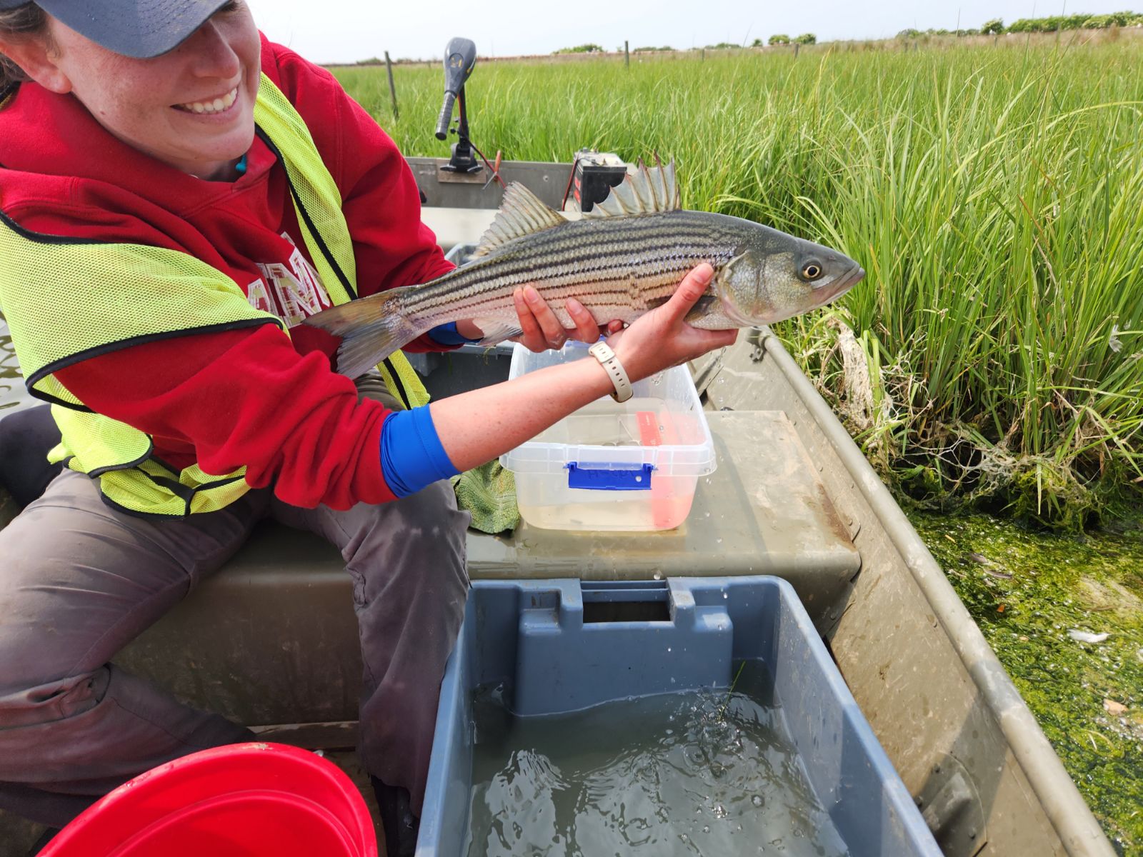
Beginning in Spring 2023, the National Oceanic and Atmospheric Administration’s National Centers for Coastal Ocean Science has been tracking fish movements throughout the marshes and embayments on Poplar Island to determine how fish are utilizing the restored habitats. NCCOS researchers are tagging dozens of fish and aquatic species with coded transmitters and are releasing them back into the wild. An array of hydroacoustic receivers deployed around the marsh act as automated data loggers and will be tracking the tagged species’ movements and locations over the next two years.
In this episode we’ll be hearing from lead NCCOS scientist Dr. Matt Kendall as he takes time out from his work at Poplar Island to tell us a little more about the project.
Here’s Matt giving us an overview of the history of the Poplar Islands in the middle Chesapeake Bay:
Matt: A little bit about the history of Poplar Island. So of course Europeans had settled in and around the Chesapeake Bay since the 1600s. The best record we have of how big Poplar Island was comes from around 1847 when a survey suggested that the land area of Poplar was around 1,100 acres. And just for reference: a football field is around 1.3 acres. So you add up a thousand of those and that’s how big Poplar Island was. By the late 1800s there were maybe 100 residents. The place had a, you know, a small town almost, if you will, but it had a post office and that sort of thing. Over the next couple of decades, however, residents began leaving as more and more land mass was lost . Why was the land mass lost? A combination of things: subsidence, where the land is sinking or compressing and getting lower; and sea level rise, which is just what it sounds like. In fact sea level has risen in the Chesapeake Bay area about one foot in the last century. Relative sea level rise in the Chesapeake Bay is about twice as fast compared to the global average. So a combination of subsidence and the rising sea level means you are going to get a lot of erosion because Poplar and a lot of islands in the Chesapeake Bay are very low lying. So more and more of the land mass is lost. And by the 1990s there’s only about four acres of island remnants and nobody lived there. In fact the place had been essentially vacant with no permanent residents since the 1940s. Where at one time it was basically just a little hunting camp. So that sort of sets the stage for you’ve got these four acres left, and the idea with this restoration project is to restore all that habitat to what it once was and even more–to 1700 acres is the ultimate goal.
Kevin: As we’ve learned, the island was once made up of one solid land mass, but that began to break into smaller islands from the effects of wind driven erosion, sea level rise, and a complicated process known as subsidence.
The last ice age occurred just 16,000 years ago, when great sheets of ice, two miles thick, covered much of Earth’s Northern Hemisphere. Though the ice melted long ago, the land once under and around the ice is still rising and falling in reaction to its ice-age burden.
This ongoing movement of land is called glacial isostatic adjustment. Here’s how it works: Imagine lying down on a soft mattress and then getting up from the same spot. You see an indentation in the mattress where your body had been, and a puffed-up area around the indentation where the mattress rose. Once you get up, the mattress takes a little time before it relaxes back to its original shape.
Even the strongest materials (including the Earth’s crust) move, or deform, when enough pressure is applied. So when ice by the megaton settled on parts of the Earth for several thousand years, the ice bore down on the land beneath it, and the land rose up beyond the ice’s perimeter—just like the mattress did when you laid down and then got up.
That’s what happened over large portions of the Northern Hemisphere during the last ice age, when ice covered the Midwest and Northeast United States as well as much of Canada. Even though the ice retreated long ago, North America is still rising where the massive layers of ice pushed it down. The U.S. East Coast and Great Lakes regions—once on the bulging edges, or forebulge, of those ancient ice layers—are still slowly sinking from forebulge collapse, or subsidence.
Here’s Matt giving us a brief introduction to the project.
Matt: We are out here at Poplar Island on the Chesapeake Bay and we are trying to understand how fish use manmade marsh habitat. Poplar Island is a really interesting spot. So this is a case of trying to kill two birds with one stone. So the Port of Baltimore and Maryland Department of Transportation need to keep the channel open that leads into Baltimore Harbor and it keeps filling in with sediment. So they have to dredge it out and they have to put that dredged sediment somewhere. So people have been experimenting with this for, uh, a while now, but it’s kind of reached a pinnacle at Popular Island where they are taking the dredged material and constructing marshes that–to the naked eye–look just like a marsh anywhere else in the Chesapeake Bay. You’ve got low marsh and high marsh with spartina and other marsh plants that should be here. You’ve got, uh–you can probably hear it in the background–there’s a bunch of seabirds that are flying all over the place that are nesting here. There’s an osprey, uh, I can see here off to my left. So what we’re trying to do is understand how the fish may be using these different, um, types of marsh habitat.
Kevin: As we have already learned, the restoration project is a partnership between the U.S. Army Corps of Engineers and Maryland Department of Transportation, Maryland Port Administration. At over seven miles in length and over a mile wide, the project is a fairly massive undertaking. Here’s Matt explaining how they build the marshes.
Matt: Alright. Let’s talk about these manmade marshes. So the way that the Army Corps and the state partners at Maryland do this is they start with a giant ring of boulders that’s maybe surrounding an area the size of a few football fields. And then they fill that in, they raise that up. That boulder ring goes up above sea level, you know, maybe 10, 15 feet and then they fill that in with all this dredge spoil as they are trying to clear out this shipping lane into Baltimore. It takes years, right? They fill it up with all of this mud. It takes years for all of this stuff to settle out and let all of the water drain out of it. And once it’s at the right thickness and height, they shape it. And they go in and they make all of these little creeks that help the water kind of flow in and out on the tide. They break some up into little islands that birds like to use. You can probably hear some of them in the background. And all of these creeks have, sort of, different characteristics. Some are long and skinny; some are short and fat; some turn a lot; some are straight. And, um, the question is: How do those different shapes serve as fish habitat? Are there certain shapes or sizes or configurations of the marsh habitat that the fish prefer? And that is what we are trying to answer. That’s the question, the objective of our study. There’s people out here studying terrapins, studying birds, studying juvenile fish. We are studying larger fish. Things that people like to catch or that have a commercial influence. Things like rockfish or, uh, white perch. Things like American eels. They use eels for, actually for stripped bass fishing.
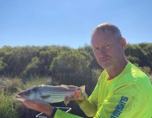
Kevin: The specific goal of Matt’s project is to try and determine which restored habitats the various wildlife most prefer, particularly the fish. Beginning in May 2023, they began attaching coded transmitters to dozens of fish and other aquatic organisms and, using an array of automated data loggers, they’ll track their locations over the next two years. Among the most important species being tracked are striped bass, white perch, gizzard shad, red drum, cownose rays, croaker, american eel, and the diamondback terrapin. Striped bass are of particular interest as they support a significant recreational and commercial fishery in the Chesapeake Bay.
The study is expected to demonstrate which aspects of the engineered and restored habitats, such as creek size, shape, and culvert type, are most used by fish and other wetland species, which will increase the effectiveness of restoration efforts. Here’s Matt explaining how they accomplish this.
Matt: So how are we keeping track of which marsh cells and which ways they have designed the marsh creeks. How do we keep track of how they like different ones? And we’re using something called Animal Tracking with Telemetry. So the way this works is we put a coded transmitter inside a fish. So we actually do a little bit surgery. Takes about a minute or two. Um catch a fish with a hook and line usually, Uh, or in a trap or a net, make sure it’s in good, healthy condition. We make a little incision in the belly of the fish and we put this coded transmitter in the fish and we sew it up. Usually just one stitch does the job. So that transmitter pings out a number that says, “I am fish number…whatever it is: five, six, seven, eight,” and it pings that code out every minute or two. And what we’ve done is install an array of acoustic listening devices throughout the marsh creeks. So if a fish swims by, and it pings out its number “I’m fish five, six, seven, eight,” Then the recording devices tell us where and when that fish is in that particular spot.
So we have all of these marsh creeks wired up with these recording devices, we’ve tagged a bunch of fish [I need to take a moment because there is a construction truck driving by that is making a bunch of noise. This is an active construction site, so dump trucks, giant bull dozers, loaders are constantly driving around, moving, uh, marsh material, moving sand and mud from one place to another] So, we’ve got all these fish moving around and we’re keeping track of where they go. We can tell things like how often they visit a cell, which parts of the cell they prefer. Do they move from one place to another in different seasons, or even day versus night? All of these are things we hope to find out at the end of this process. The objective is to figure out which aspects of these manmade marshes these large fish prefer to use. And the idea being that hopefully with this information the Army Corps and Maryland Department of Transportation can better, be better informed about how they can do this kind of project in the future.
Kevin: Not only is the project providing a location to deposit dredge spoil and restore lost habitat for local wildlife, the project has other benefits for the region.
Matt: One of the benefits of this island is that it provides shoreline protection for communities that are along the Eastern Shore that face this part of the bay. Um, places like Tillman Island and Napta Narrows. Those are going to get way less wave energy because this island has been put here. There’s a couple of little islands here, Coaches Island and Jefferson Island, that, um, were slowly disappearing under the waves of the bay as sea level rise and land subsides.
Kevin: With the huge budgets projects like these require, many in the public very reasonably ask “why?” Why do we care so much about some disappearing islands in the Chesapeake Bay? Islands most taxpayers in the region will never see, much less benefit from directly. Matt explains why we should care.
Matt: So why do we keep talking about the marsh? Why do we care so much about the marsh? So this island is doing a few things, right? It provides a place to put the dredge spoil. So that’s one benefit of it. This island is providing shoreline protection for Tillman Island by breaking the energy of waves as they come ashore, reducing the land erosion where everybody lives. Um, and then it also provides habitat, right? Not only for the birds, but for the fish. And it’s this meadow of marsh grass. Why do we care about the marsh so much? The marsh is basically this large gas tank or fuel tank that runs the ecosystem of the bay for a large part. All of that grass is basically burning energy from the sun into things a lot of little critters can eat. All the snails, all the crabs, all the isopods. All that stuff is feeding on the base of the food chain in the marsh grass, then all those little critters feed small fish, that in turn feed larger crabs, that in turn feed, uh, larger fish. So all of the sudden with this big fuel tank that is the marsh, we have the base of the food chain that is what people care about and think about when they think about the Chesapeake Bay: blue crabs, stripers, things like that. Um, so, that’s why we care about the marsh.
Kevin: Lastly, Matt explains some of the challenges and rewards of working on an island two miles offshore with limited facilities and its own unique set of complicating factors.
Matt: One of the things I find challenging about projects like this is also the most fun and that is figuring out how to catch a diversity of local fish species in places that usually I haven’t been fishing and haven’t worked. But you have to catch them and make sure the fish are in really good physical condition so when we tag them, they survive and they give us good movement data just like any other healthy fish in the ecosystem would. So we always start this process by asking local fishermen about best fishing techniques for different species. Sometimes it’s traps or nets, sometimes it’s rod and reel, hook and line, um, with a particular lure or bait. And that’s really when the fun starts because mainly it’s a lot of fun trial and error to see what works best in the particular place where we work. So for example at Poplar–really anywhere–gizzard shad can only be caught in briefly set gillnets. You’ve got to catch them fast and get them out of the net pretty quick so they are in good condition and they don’t get all tangled up in there. Eels, on the other hand, can really only be caught in eel pots or big eels can be caught in hoop nets. In the case of white perch and red drum, those are susceptible to the nets but you can get them in better condition by, uh, hook and line. By rod and reel with certain types and colors of spinner lures. Same thing goes with the stripped bass.
Kevin: A major economic benefit of the project is its ability to continuously accept dredge spoil from the Port of Baltimore. Any disruption in the near constant maintenance and removal of dredge spoil that is required to keep the Port of Baltimore operational would result in significant adverse effects to both the local and national economy. The port handles approximately 30.8 million tons of commerce per year, contributes $1.9 billion in business to the state’s economy and generates 50,200 jobs, 16,500 of which are directly related to port activities. Revenue impact from the port represents one-tenth of Maryland’s gross product. The Port of Baltimore is also ranked number one in the U.S. for automobile exports.
The Poplar Island restoration effort will continue to accept dredged material until 2029. Habitat restoration is expected to be completed by 2041 at a cost of approximately $1.4 billion dollars. Upon completion, the restoration will result in 1,715 acres of developed wetland, upland, and open water embayment habitats. As Poplar Island continues its resurgence, engineers, scientists, and others from around the country will closely monitor its success.
For more information about NOAA’s work in the Chesapeake Bay, explore the links on the main landing page where you found this podcast. To learn more about NCCOS’s role in these efforts or about all the other great coastal ocean science being conducted by NCCOS, please visit our website at coastalscience.noaa.gov. Thank you for listening!
[Waves crashing]