Uncrewed Systems for Mapping
Uncrewed systems, or more commonly UxS, encompass a wide array of vehicle types—aerial, terrestrial, or marine (surface and underwater)—and associated elements, such as sensors and communications software, that can execute data-collection missions without human presence aboard. Uncrewed systems can provide an efficient, viable, and cost-effective means of meeting science requirements and augmenting the capabilities of traditional platforms such as aircraft, ship, and satellites. Additionally, UxS can greatly improve the extent to which high-resolution bathymetry, habitat ground-truthing, and animal observations can be obtained in the coastal zone. NCCOS has made tremendous progress in developing and incorporating the use of UxS in a variety of applications.
Shallow-water Mapping and Monitoring
Small Uncrewed Aircraft Systems (sUAS) provide efficient and rapid access to coastal environments where traditional systems are costly to deploy or are unable to navigate, particularly for remote and shallow locations. sUAS typically deploy optical camera payloads that can be used to construct highly detailed photomosaics and digital elevation models using Structure from Motion (SfM) software. NCCOS has developed guidelines to operationalize this approach and has led regional workshops to establish communities of practice; and is in the process developing low-cost, easily deployed, and accurate harmful algal bloom (HAB) detection sensors to provide real-time information to shore-based scientists.
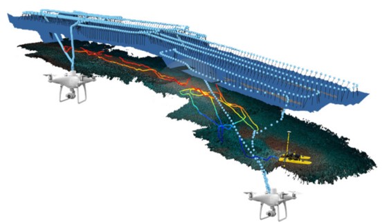
Acoustic Surveys From UxS
NCCOS uses surface and underwater UxS to survey seafloor habitats in coastal waters and in navigationally challenging areas. We also use UxS to conduct long endurance surveys along the coastal shelf. Active and passive acoustic sonars can be instrumented on these vehicles to map bottom habitats and topography; and track and quantify marine life abundance.
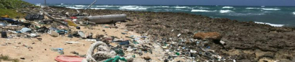
Object and Animal Detection
NCCOS is also developing automated object detection and classification workflows for UAS imagery using artificial intelligence. The objective is to develop and implement operationally-efficient workflows and deployable algorithms to provide rapid analysis and identification of objects such as habitat type, marine animals, or marine debris. Additionally, NCCOS and partners are investigating the utility of advanced sensor payloads, such as polarimetric cameras, to improve detection accuracies of object types.