NCCOS has completed a seafloor characterization study for the Bureau of Ocean Energy Management (BOEM) in support of a $3 billion offshore wind energy project in the coastal waters of New York expected to build 60–80 wind turbines, create 800 local jobs, and power over 500,000 homes. BOEM leased the New York Wind Energy Area (NYWEA), located south of Long Island, to Equinor Wind US LLC in December 2016 for development of the 816-megawatt project.
NOAA has joined with BOEM to help build a secure and sustainable domestic energy supply in support of the Blue Economy, a concept that encourages better stewardship of ocean resources. The U.S. is home to one of the largest and fastest growing wind markets in the world, investing in land-based and offshore wind research and development projects to advance technology innovations, create job opportunities, and boost economic growth.
The NCCOS assessment provides baseline habitat and geologic information within NYWEA and the New York Bight region to help managers better evaluate the potential impacts of offshore wind development, and identify additional potential wind energy sites in the region. The NYWEA furthers New York’s objective to generate 50 percent of its electricity from renewable energy by 2030, and to implement a comprehensive Offshore Wind Master Plan.
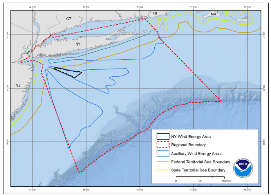
The research team conducted extensive acoustic and sediment sampling, and ground validation studies within NYWEA. The regional study area encompasses 50,082 square kilometers of coastal and ocean waters off the coast of New York (Figure 1). The researchers used ship-based multibeam sonar, sediment grabs, and fishery acoustics surveys to acquire the detailed information needed to characterize seafloor composition and map seafloor habitat, as well as to characterize fish abundance and distribution in the area.
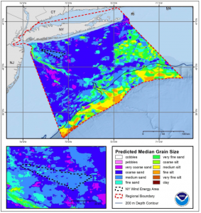
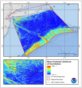
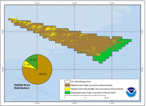
The final report includes a complete analysis of hard bottom predictions, habitat, and sediment texture. Using spatial predictive modeling, the researchers created maps that show the likelihood of hard bottom occurrence (Figure 2), the distribution of surface sediments (Figure 3), and habitat predictions (Figure 4). The findings verify that the area is primarily sand sediment with little hard bottom and limited presence of economically important fish or shellfish. The team found very few biological or geological resources that could be permanently impacted, making the area conducive for wind farm infrastructure siting.
Project partners included NCCOS; the Bureau of Ocean Energy Management; the Institute of Arctic and Alpine Research at the University of Colorado, Boulder; and student interns.
For more information, contact Tim.Battista@noaa.gov, or visit the project webpage.