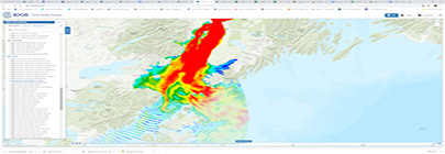
Actea produces site-specific and regional analysis of ocean climate change and its impact on marine species, including those economically important to coastal aquaculture. Actea’s model has global coverage.
Aquaculture Application: Actea can provide an interactive map tool which displays climate projections to assist with site location. Actea can produce climate risk reports for specific sites and can model aggregate climate risks across multiple sites. Check out the Actea Data Explorer tool demo!
Contributing partners: Actea, Inc., Farallon Institute
Can be used to examine near and far field effects of individual or clusters of farms in the coastal shelf where nearshore or open-ocean aquaculture may develop. The software models farms with multiple, separate cages and multiple farm sites to meet this challenge.
Aquaculture application: AquaModel allows for proper planning, siting and management of offshore aquaculture farms to monitor and reduce environmental impacts to marine ecosystems.
Requirements: Technical training and purchase of AquaModel Software
Contributing Partners: EASy
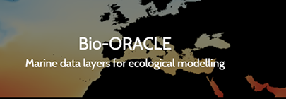
Linking biodiversity occurrence data to the physical and biotic environment provides a framework to formulate hypotheses about the ecological processes governing spatial and temporal patterns in biodiversity, which can be useful for marine ecosystem management and conservation. Bio-ORACLE offers a user-friendly solution to accomplish this task by providing 18 global geophysical, biotic and climate layers at a common spatial resolution (5 arcmin) and a uniform landmask.
Aquaculture application: Oceanographic and biophysical data at depth, helping to determine if needed environmental conditions are in place for five to ten year aquaculture permit.
Contributing Partners: Ghent University, LifeWatch, VLIZ, CCMAR
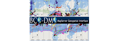
The Biological and Chemical Oceanography Data Management Office (BCO-DMO) staff members work with investigators to serve data online from research projects funded by the Biological and Chemical Oceanography Sections, the Division of Polar Programs Arctic Sciences and Antarctic Organisms & Ecosystems Program at the U.S. National Science Foundation.
Aquaculture application: Wide range of datasets on different geographical, geophysical, biological, and environmental data to inform aquaculture planning.
Contributing Partners: National Science Foundation
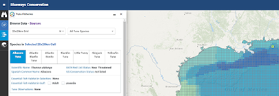
The Blueways Conservation Decision Support Tool offers a wide range of information about ocean resources and management. The focused apps and extensive spatial layers available are valuable tools for enhancing biodiversity, ecosystem-based management, and healthy human activity in the ocean. These resources may serve to support decision-making by marine planners, resource managers, commercial and recreational fishermen, and many other industries using the ocean.
Aquaculture application: Use of spatial technologies and data on existing energy planning, regulated fisheries locations, and regional marine planning to inform aquaculture planning.
Contributing Partners: The Nature Conservancy
Zoned tides, relative to a tidal datum, can be constructed by applying time and range correctors to observed water level data from a given NOAA tide station for corrections.
Aquaculture application: Users can view and download tidal corrections for planning of shellfish aquaculture farm locations relative to the needed balance of submerged and exposed gear.
Contributing Partners: National Ocean Service (NOS) Center for Operational Oceanographic Products and Services (CO-OPS)
Create a map of potential ecological, social, and economic impacts from rising seas and changing climate.
Aquaculture application: Map aquaculture coastal planning efforts and evaluate resiliency options.
Contributing Partners: ASFPM, Natural Capital Project, TNC, NOAA OCM, USGS, UCSC, USM
View Product
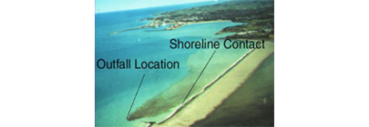
Cormix Is a USEPA-supported mixing zone model and decision support system for environmental impact assessment of regulatory mixing zones resulting from continuous point source discharges. The system emphasizes the role of boundary interaction to predict steady-state mixing behavior and plume geometry.
Aquaculture application: Assists in the site selection of aquaculture facilities located in close proximity to point source discharge.
Contributing Partners: MixZon Inc
A biogeographic classification of the world’s coastal and continental shelf waters following a nested hierarchy of realms, provinces and ecoregions.
Aquaculture application: Descriptive information about ecoregions is useful for planning and development of aquaculture activities.
Contributing Partners: Data Basin, TNC
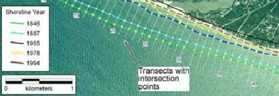
Allows users to visualize computational data on the rate of shoreline change using multiple historical shoreline positions.
Aquaculture application: Assesses the effects of moving shorelines on nearshore aquaculture siting.
Requirements: Software – ArcGIS 10.X, Download
Contributing Partners: USGS
Allows users to view, retrieve, visualize and analyze a wide range of estuarine data from multiple authoritative sources.
Aquaculture application: Interactive software application for water quality conditions for screening and siting aquaculture.
Requirements: Download
Contributing Partners: EPA
View Product
IOOS data comes from a variety of technologies or data collection systems. While types of data available through any one of our 11 regional associations may vary depending on the local area, the national IOOS data products include data collected from buoys, high frequency radar systems and gliders. Modeling teams across regional associations also create data products including physical and environmental models of coastal systems.
Aquaculture Application: Useful for visualizing oceanographic conditions and forecasting for aquaculture development.
Contributing Partners: NOAA IOOS
Supports conservation planning design and evaluation through the development of multiple-use areas and plans for natural resource management.
Aquaculture application: Employ this tool to meet ecological, social, and economic objectives for coastal aquaculture planning.
Requirements: Download
Contributing Partners: University of Queensland Australia
Vertically transforms geospatial data between a variety of tidal, orthometric, and ellipsoidal datums, for high-resolution data products
Aquaculture application: Accurately map areas for aquaculture siting, and create high-resolution bathy topo maps through VDatum transformation.
Contributing Partners: NOAA CO-OPS, NOAA NGS, NOAA OCS
View Product
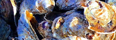
By combining state of the art hydrodynamic models with specific algorithms for Vibrio (a foodborne bacteria that causes gastroenteritis or worse), we can provide early warning of these potential coastal hazards.
Aquaculture application: Models have been assembled to predict safe harvest of shellfish around the nation. Knowing where and when to expect elevated concentrations of Vibrio, and environmental conditions that promote rapid growth can inform both management and individual grower harvest decision making.
Contributing Partners: NCCOS