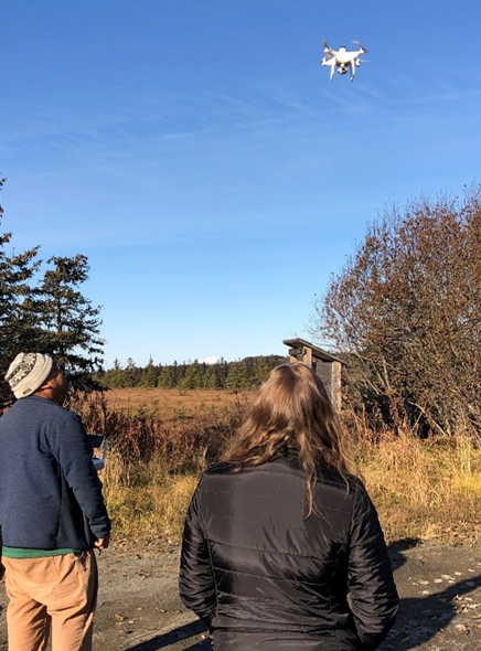
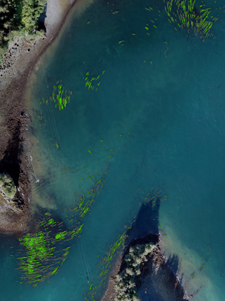
Nearshore habitats are important sources of food, shelter, and services that support diverse ecosystems. Cook Inlet and Kachemak Bay host a variety of these marine habitats, including kelp forests, seagrass meadows, and salt marshes. We are mapping the region using drones, ROVs, and SCUBA surveys to understand how these habitats are distributed and how they change over time. The information we collect will support management of the area by state, federal, and tribal partners.
Why We Care
Coastal habitats support countless marine and estuarine species, offer protection from erosion and flooding over thousands of miles of coastline, and provide resources for humans, including productive fisheries and opportunities for recreation. In the U.S., the coastal environment is a diverse mosaic of dozens of habitat types that each provide their own unique services.
For example:
-
- Kelp forests are habitat for many fish species, including rockfish, lingcod, and salmon. They are also hotspots of biodiversity that strengthen the marine community’s resistance to habitat loss.
- Seagrass meadows are nurseries for crustaceans and fish, providing shelter for many species during vulnerable life stages. They also stabilize loose sediment and sequester carbon dioxide from the atmosphere.
- Salt marshes filter excess nutrients and other pollutants from the water. They are also critical stopover sites for migrating birds.
Understanding how these habitats are arranged across the seascape and tracking how they change through time allows us to predict the impacts of disturbances such as storms and warming waters on habitat resilience and diversity. This in turn gives us information that can be used to reduce the harmful effects of these disturbances across our coasts, and make choices that support the ecological and commercial productivity of our waters.
In Alaska, and particularly in Cook Inlet, marine habitats are critical sources of food and economic stability that are at risk from changing climate conditions. Assembling a baseline for current habitat distributions across the state is vital to safeguarding our valuable marine resources.
What We Are Doing
To understand how marine habitats in Alaska are arranged and how they might change in the future, we are focusing our efforts within Kachemak Bay in Cook Inlet and conducting repeated surveys on a seasonal and annual basis across multiple marine habitat types. Our goal is to create “living” habitat maps that will be used to inform local decision making regarding commercial and subsistence fisheries, shoreline infrastructure, and environmental protections. We are doing this by:
-
- Engaging with local partners, including the Kachemak Bay National Estuarine Research Reserve, Seldovia Village Tribe, and Chugach Regional Resources Commission to determine community needs
- Identifying known critical habitat types and locations that have current or historic value to create a list of “focal sites” to be surveyed
- Using drones, ROVs, and SCUBA surveys on a seasonal and annual basis to produce imagery and ecological community assessments of focal sites
- Creating high-quality maps and habitat summaries that will be provided to community members describing the present condition of focal sites, and predictions of how those sites might change with changing climate
To truly capture change on a meaningful time scale this project is ongoing, with the aim of monitoring these habitats over many years.
Benefits of Our Work
A comprehensive habitat map of Kachemak Bay with measures of seasonal and annual change across years will be an invaluable decision making resource for local, state, and tribal governments. In addition, opportunities to engage the general public, students, and interns with our work will raise awareness and promote stewardship of our valuable marine resources, and train the next generation of scientists.
Next Steps
As our research plan develops, we look forward to building our capacity and extending the reach of our efforts. This will include:
-
- Increasing the number of focal sites within Kachemak Bay to capture finer-scale seasonal and annual changes in habitats
- Expanding our surveys to other locations within Cook Inlet
- Forming new partnerships with research and education groups across Alaska to further expand the geographic scope and impact of the project by sharing methods and outcomes
- Developing new products, such as GIS tools and interactive story maps, to reach more decision-makers and community members across the state and beyond