Forecasting harmful algal blooms is a complex endeavor involving a wide range of oceanographic disciplines. NCCOS scientists and sponsored researchers count the number of harmful algal bloom (HAB) resting stages or cysts that lie on the bottom of the ocean as one method to estimate the future occurrence of HABs.
Scientists use a suite of oceanographic instruments and techniques to estimate the present and future abundance of HAB cells and their toxins: remote sensing (aircraft and satellites), flow cytometers (e.g., Imaging FlowCytobot ), analytical chemistry, phytoplankton nets, automated water samplers, cabled sampling arrays (e.g., Environmental Sample Processor ), robotic underwater instruments (e.g., gliders ), models, and corers and grabs to sample the seafloor.
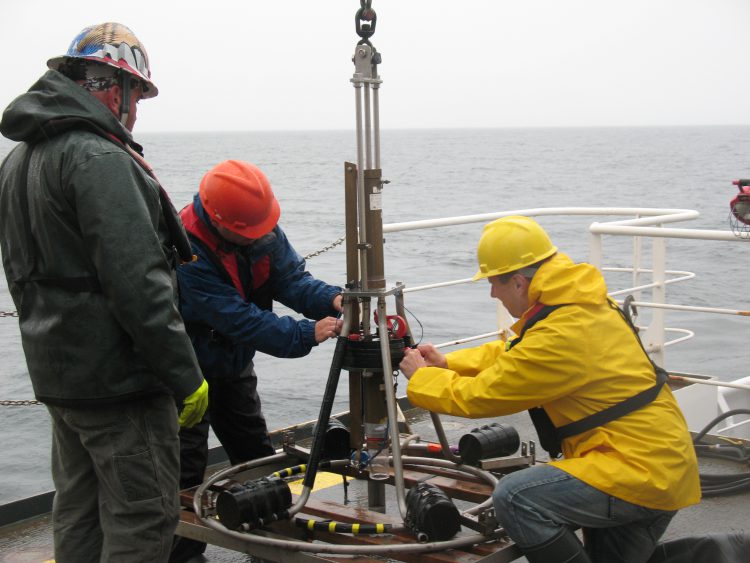
NCCOS counts the number of Alexandrium resting cysts overwintering on the seafloor to help forecast blooms that cause paralytic shellfish poisoning (PSP). The device used to the sample the cysts is called a ‘Craib Corer.’ The Craib Corer (named after its inventor, J. S. Craib of the University of Millport Marine Biological Station, Scotland) gently collects an undisturbed single core sample from the top 12 centimeters of bottom surface sediment where the cysts lie. The corer, made of brass, mounts on a light stainless steel, galvanized finish frame (< 300 pounds), handles easily, and uses a range of acrylic core tubes. Upon impact with the bottom, the winch operator reduces the cable tension, and the hydraulic-damped core barrel penetrates the sediment.
After about 10 seconds, the cable slack is taken up, the corer gently extracted from the sediment, and pulled back to the surface. Once back on the ship deck, they remove the corer and take the top three centimeters of sediment off the top of the core tube. They sieve the sample to remove sediment and debris and preserve the remaining cysts for future counting. Matching sample locations with cyst counts produces areal maps of cyst abundance for resource managers and provides data for the forecast models.
NCCOS is using data from Craib Corers to produce cyst maps and improve the accuracy of models for planned operational forecasts of Alexandrium blooms in the Gulf of Maine and in Puget Sound, WA. Ten minute videos of Craib Corer deployments in Puget Sound and the Gulf of Maine show the Craib Corer in action under water.
For more information, contact Terry.McTigue@noaa.gov.