A new NCCOS sponsored study published in Geophysical Research Letters found saltwater wetlands generally more resilient than freshwater wetlands. Using remote sensing to determine how saltwater flooding and high winds from hurricanes and periods of extreme drought can stress and alter marshes in Apalachicola Bay, Florida, the study found systems recover more quickly from drought (months) than hurricanes (one year or more).
Remote sensing, using a suite of satellite sensors, can be used to detect and track wetland community dynamics over long time periods. The data, converted into indices, can be used to identify and characterize vegetation. One popular and frequently used index is the Normalized Difference Vegetation Index (NDVI). Coupled with the NOAA Coastal Change Analysis Program (C-CAP) habitat classification methodology, researchers used NDVI to study three wetland vegetation types: Freshwater Forested, Freshwater Emergent, and Saltwater. Although scientists have previously studied the effects of wind, storm surge, and salinity on wetland ecosystems, the difference between salt and freshwater wetlands remains largely uninvestigated. From approximately 2000 to 2015 scientists studied the impacts of four hurricanes and one drought. Computing the NDVI before and after these extreme hydrologic events showed changes in vegetation and its recovery rates.
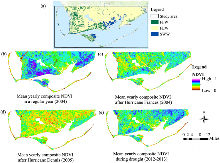
The study results showed hurricanes caused NDVI trends lasting a year or more. Recovery from the drought period was much shorter requiring only one month to baseline levels. Scientists observed freshwater wetlands as less resilient than saltwater wetlands showing larger reductions in the NDVI.
This study showed that under projected climate change and sea level rise, wetlands may be more vulnerable to change and experience significant ecological consequences than previously believed. The results can be incorporated into management models for analyzing restoration, monitoring, and ecosystem service scenarios. Management responses may include, for example, more upstream freshwater releases to flush saltwater storm surge from freshwater wetlands.
A study was partly funded by the NCCOS Ecological Effects of Sea Level Rise Program (EESLR) project in the Gulf of Mexico.