As U.S. cities face risks of flooding, property owners, utility companies, and insurers increasingly will need to rely on the best available hazard predictions to make decisions that maximize safety and minimize economic loss.

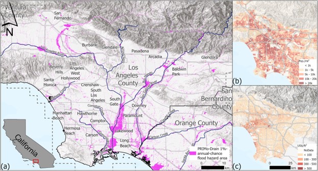
A National Centers for Coastal Ocean Science (NCCOS)–supported research team created a regional model that estimated flood risks at a neighborhood-scale for California’s Los Angeles County. The researchers found that previous publicly available models that rely on national-scale data may underestimate and even misrepresent hazards. Recognizing the need for localized risk assessment, both the office of the Governor of California and the regional utility company Southern California Edison have adopted the research team’s methodology as their preferred approach for predicting flood risks statewide.
The updated model incorporated property values, socioeconomic data, and local drainage infrastructure — like storm sewers — in specific locations in order to better understand how flood risks impact communities. Model results showed that larger swaths of Los Angeles County, especially denser, lower-income neighborhoods located in the Los Angeles River floodplain, are at a higher risk of flooding than earlier models predicted.
The models compared in the study agreed only about 20 percent of the time. Previous models had shown higher-income neighborhoods located in hills and canyons to be at a higher risk. The updated model found some of these hillier neighborhoods to be vulnerable to floods. However a low overall agreement between the two models suggested that risk prediction should incorporate regional information at finer resolutions to improve reliability.
Originally published in the scientific journal Earth’s Future, journalists have cited the study in popular news outlets outlining how insurance companies often make decisions about which homes are insurable and at what cost based on models made by private companies that are not publicly available. The writers argued that a more detailed, public-facing approach to regional risk mapping, such as the one used in this study, might help resolve differences between the model outputs.
This project was led by the University of California, Irvine and the University of Miami, and funded through the NCCOS Effects of Sea Level Rise (ESLR) Program. Project partners include the Los Angeles County Department of Public Works, the California Department of Water Resources Floodplain Management Branch, the California State Coastal Conservancy, the California Coastal Commission, and the Los Angeles Regional Collaborative for Climate Action and Sustainability.
Citation: Schubert, J. E., Mach, K. J., & Sanders, B. F. (2024). National‐Scale Flood Hazard Data Unfit for Urban Risk Management. Earth’s Future, 12(7). https://doi.org/10.1029/2024ef004549
This work is authorized by the NOAA Authorization Act of 1992, Pub. L. 102-567 (Oct. 29, 1992); sec. 201(c), which authorizes appropriation for the Competitive Research Program to augment and integrate existing programs of NOAA and shall include efforts to improve predictions of coastal hazards to protect human life and personal property.
