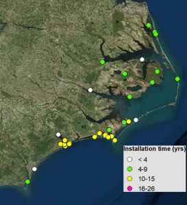
Surface Elevation Tables, or SETs, are used to study changes in marsh surface elevation. These devices are attached to a fixed benchmark and measure millimeter changes in elevation. There are over 125 SETs in coastal North Carolina that provide critical information on how marshes are changing as a result of sea level rise, yet the data from these devices are collected by different organizations that are not necessarily coordinating efforts.
That all changed when the NOAA Sentinel Site Program commissioned Drs. Jenny Davis and Carolyn Currin from the National Centers for Coastal Ocean Science Beaufort Lab to create an inventory of SETs for the five Sentinel Site Cooperatives (SSC), one of which is located in the central coast of N.C. This effort aligned perfectly with a goal of the N.C. SSC, identifying existing resources that could contribute to understanding sea level rise trends. “A number of SETs in North Carolina were installed to answer short-term research questions,” says Davis. “But once installed, SETs can be measured repeatedly at varying intervals through time to allow long-term trends to be observed.”
As SSCs in the northern Gulf of Mexico and Chesapeake Bay began to coordinate SET data, it made sense to follow their lead and coordinate efforts in N.C. In December 2017, the North Carolina Coastal Reserve & National Estuarine Research Reserve (NCNERR) assisted the N.C. SSC in hosting a webinar to gauge interest in establishing a collaborative network in N.C. to compile and analyze the SET data. Webinar participants resoundingly agreed that a collaboration in N.C. would be beneficial.
In May 2018, the NCNERR hosted a SET operator coordination meeting with partners including the U.S. Fish and Wildlife Service, National Park Service, N.C. State University, Carolina Wetlands Association, UNC Institute of Marine Sciences, East Carolina University, The Nature Conservancy, and Chowan University. The group agreed that the collaboration should start with finalizing the SET inventory that Drs. Davis and Currin began; analyzing the existing SET data to look for trends as well as generate research questions; and creating an open forum to help trouble-shoot the management of SET sites.
The end goal of this work is to determine what is happening to our coastal marshes – are they keeping up with sea level rise or are they drowning. This information will help resources managers make decisions on where to direct efforts to protect these important coastal habitats.
For more information about this effort, contact Whitney Jenkins with the NCNERR at whitney.jenkins@ncdenr.org or 252-838-0882.