A new online tool developed by the University of South Carolina, with funding through NCCOS’s Ecological Effects of Sea Level Rise program (EESLR), allows users to evaluate scenarios of coastal salt marsh health under a suite of sea level rise conditions. In addition to visualizing results through the web interface, users can download the results to create enhanced graphics for communicating results.
Users can input data relevant to any salt marsh across the country, although, the data contains pre-calibrated settings for five estuaries, including Apalachicola and Grand Bay National Estuarine Research Reserves. These data are from field studies and adjust to represent a number of sea level rise and management scenarios such as: evaluation of marsh health and longevity through the addition of beneficial use sediments, impacts of measures to increase natural sediment deposition, and carbon sequestration potential.
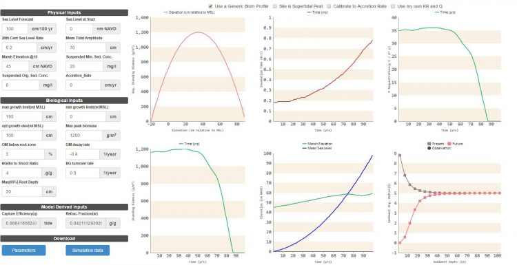
The online tool is built on the latest version (5.4) of the Marsh Equilibrium Model (MEM). MEM evaluates the relationship between a suite of physical (e.g., water level and total suspended solids) and biological factors (e.g., marsh health and biomass production) over time. This zero-dimensional model is coupled with a hydrodynamic model (ADCIRC) to create a dynamic 2-dimensional marsh model called Hydro-MEM. Together these models advance our understanding of the complex relationships among coastal marshes, sea level rise, and hydrodynamics. Advancement of MEM and development of Hydro-MEM are two products from a long-term EESLR project in the northern Gulf of Mexico.