Offshore sand resources, e.g., sand shoals, are increasingly being used for beach renourishment, barrier island restoration, and other uses to enhance resiliency of shorelines. However, the impact of sand dredging on fish and other marine resources is poorly understood. We are working with the Bureau of Ocean Energy Management and NOAA’s National Marine Fisheries Service to provide information on these effects and to develop a geospatial decision support tool that helps users determine the relative risk to fisheries that are associated with extraction of these sand resources.
![]()
Why We Care

- Offshore sand resources, including sand shoals, are increasingly being used for beach renourishment, barrier island restoration, and other uses that enhance coastal resiliency in the face of major storms and hurricanes.
- The Bureau of Ocean Energy Management (BOEM) is charged with the environmentally responsible management of Outer Continental Shelf resources (e.g., sand and gravel, renewable energy, oil and gas). Federal jurisdiction starts at three nautical miles (nm) offshore of most states, with the exception of Texas and the Gulf coast of Florida, where it starts at nine nm.
- As the demand for Outer Continental Shelf sand increases, BOEM is facing increasingly complex issues, such as resource allocation, cumulative impacts from repeated use, space/use conflicts, protection of archaeological sites, and Essential Fish Habitat impacts. In particular, the Magnuson-Stevens Fishery Conservation and Management Act requires that any federal agency undertaking or authorizing an action that may adversely affect Essential Fish Habitat or federally managed fish species consult with NOAA.
- It is critical that BOEM uses the best available science in their environmental assessments of lease requests, so that all necessary and effective precautions are taken to reduce potential impacts during sand dredging and conveyance to placement sites.
What We Are Doing
- We are collecting and synthesizing all available literature on the effects of sand dredging on fish species and other related living marine resources. This will include peer-reviewed scientific research publications, government reports (e.g., BOEM, Army Corps of Engineers, and U.S. Geological Survey), localized studies, and previous environmental assessments. The synthesis will include an examination of specific fish groups, such as demersal-, forage-, and pelagic fishes, as well as potential food web impacts related to sand dredging.
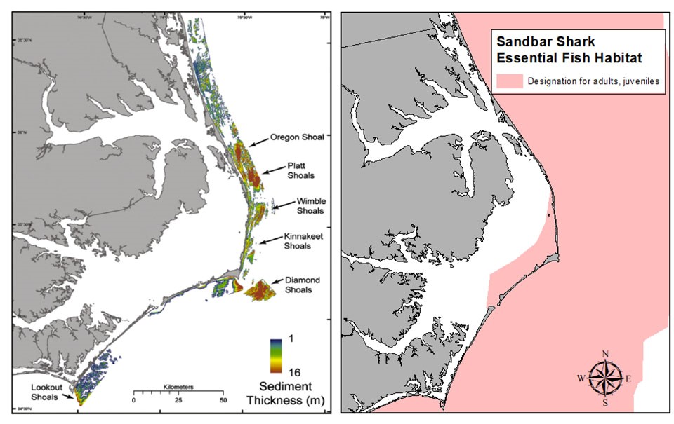
- A geospatial decision support tool will include available fisheries, geological, and oceanographic data compiled in a format to help define and evaluate potential relationships between Essential Fish Habitat and marine geomorphology (e.g., bottom substrate, topography). Then, we will relate these findings to dredging activities on the Outer Continental Shelf. To this end, we will use available fish distribution data and develop additional maps from available data sources to fill in appropriate information gaps.
- We will use and develop geospatial maps to investigate the link between geomorphologic features (e.g., sand shoals) and Essential Fish Habitat, to better analyze the potential impacts of sand relocation.
- Workshops will be conducted with staff of the National Marine Fisheries Service and regional Fishery Management Councils to help determine the best data and options for an online mapping tool to assess the relative risk to fisheries associated with sand resources. This will ensure that the mapping tool is consistent with their mandates.
- This project continues decades-long work by NCCOS in developing biogeographic assessments and geospatial tools to support federal agencies and partners in the management of coastal ecosystems.
Benefits of our Work
Our research will help natural resource management agencies make informed decisions about potential sand relocation projects and their alternatives. Our map-based web tool will provide users with transparent access to in-depth information on the distribution of fish combined with the distribution of sand resources.
The project will result in the following products:
- a literature synthesis that will provide a citable reference for future sand shoal dredging projects and their impact assessments,
- an online geospatial tool with GIS layers for the Atlantic Ocean and the Gulf of Mexico,
- a peer-reviewed paper is expected, and
- presentations to BOEM and other federal agencies.
Project Update
In January 2021, at the MAPPS Winter Meeting, NCCOS and partners received a special honor award for the project’s geo-spatial decision-support tool “ShoalMATE,” used to guide wise use and dredging of offshore sand shoals. The honor award is part of the MAPPS 14th Annual Geospatial Excellence Awards. “MAPPS” is the preeminent national association of firms involved in many aspects and benefits of the geospatial field in the United States.