Wilson Bay in Jacksonville, NC was transformed from a polluted waterway to a healthy wetland ecosystem by a community-wide partnership. To assess the success and future health of the restored wetlands, a multidisciplinary team is tracking the habitat restoration site. Partners include NOAA’s National Centers for Coastal Ocean Science (NCCOS), University of North Carolina Institute of Marine Sciences (UNC IMS), the City of Jacksonville’s Stormwater Division, N.C. Sentinel Site Cooperative, and the Department of the Navy.
Two ecosystem functions, shoreline stabilization and nitrogen removal, are the focus of the group of researchers and community representatives along with if those functions can keep up with future challenges such as sea-level rise. The reintroduction of oysters to the bay following the cessation of waste input put the restoration of nine acres of coastal wetlands in motion 20 years ago.
‘Communities in California, New York State and the Chesapeake Bay area have contacted me to ask about what we did to restore Wilson Bay,’ Pat Donovan-Potts, stormwater manager for the City of Jacksonville, shared with Coastwatch.
Even healthy wetlands must be able to handle erosion forces such as storms and rising sea level. This is where NCCOS scientist, Carolyn Currin, came into the partnership. Currin and Donovan-Potts installed surface elevation tables, or SETs, last summer to assess if Wilson Bay is handling these forces.
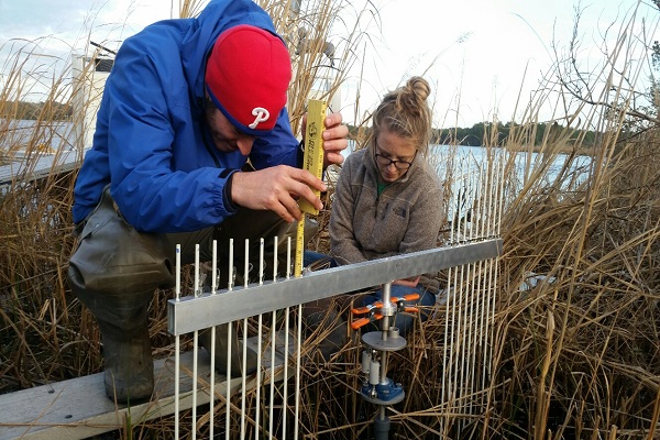
‘NOAA personnel trained the Jacksonville team on SET reading,’ Currin says. The maintenance and data collection was turned over to city employees in January 2017. The Wilson Bay SET will be part of a national network that measure elevation over time in restored and natural marshes. This SET is particularly important because it is the only one located near the head of an estuary, which will elucidate how marsh elevation in inland estuarine settings changes over time.
The project is now incorporated into programs taught to hundreds of students at a local environmental education center, Sturgeon City, located in the old wastewater treatment plant in Wilson Bay.
For more information, please contact Carolyn Currin.