At the 2021 Esri Federal GIS Conference, two newly developed NCCOS spatial analysis products were acknowledged as GIS tools having a positive impact on human society and wellbeing. NCCOS’ Alaska Spatial Bibliography and Coral Conservation and Management Dashboard were specifically called out.

For the annual Federal GIS Conference, Jack Dangermond, founder and president of the Environmental Systems Research Institute (Esri), opens the plenary session by spotlighting some of the maps, applications, models, and story maps created by state and federal agencies. In this year’s virtual (2021) plenary session, he called the web-based Alaska Spatial Bibliography and the Coral Conservation and Management Dashboard two favorite examples, among others, of GIS interactive applications.
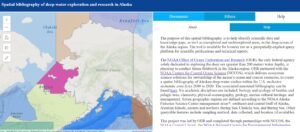
The Alaska Spatial Bibliography allows users to browse and explore over 300 scientific publications and technical reports on Alaska’s deep-water exploration and research. The application, built by NCCOS and the NOAA Office of Ocean Exploration and Research (OER), contains querying capability to filter the publications by region, author, locations, sampling types, collection methods, and discipline.
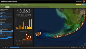
The Coral Conservation and Management Dashboard utilizes a combination of maps and charts to help users visualize and query coral data from multiple monitoring programs in National Park areas in Florida and the U.S. Virgin Islands. The dashboard, built collaboratively by NCCOS and the U.S. National Park Service, provides NPS with a one-stop source for information on the numerous coral monitoring programs across federal, state and territorial jurisdictions. The dashboard covers land cover, bleaching and disease data, including photo images. Options include 3D viewing and downloading data.
Mr. Dangermond’s 2021 plenary session talk can be viewed here. The NCCOS/NPS Coral Conservation and Management Dashboard is mentioned at about minute 4:15 and the NCCOS/OER Alaska Spatial Bibliography is mentioned at about minute 10:43.