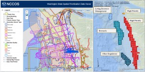
NOAA’s National Centers for Coastal Ocean Science have developed species distribution maps and a seafloor mapping inventory to help guide marine spatial planning in the state of Washington. Marine spatial planning is a process that brings together multiple users of the ocean – including energy, industry, government, conservation, and recreation – to make informed and coordinated decisions about marine resources.
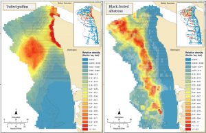
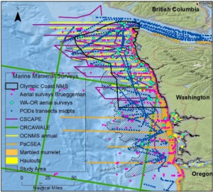
Using modeling that linked at-sea observations with environmental data, the teamcreated seasonal distribution maps of key seabird species off the Pacific coast of Washington. The researchersalso developed aninventory of all marine mammal surveys off the coast of Washington, which they are analyzing to create similar distribution maps for marine mammals. Finally, the team built an online geospatial data viewer of existing seafloor mapping information for Washington’s outer coast to allow planners to prioritize future seafloor mappingand to allow users to easily evaluate the extent, type, and quality of existing seafloor data.
The seabird distribution maps and the seafloor mapping inventory are available now, and the marine mammal distribution maps will be available by the end of 2015.
For more information, contact Charles.Menza@noaa.gov.