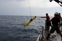
This summer, NCCOS-sponsored scientists from Texas A&M University will test the use of gliders to monitor and map hypoxia in the northern Gulf of Mexico. The team will deploy five autonomous underwater vehicle gliders and one autonomous surface vehicle over the Louisiana coastal shelf and associated offshore region, while also taking shipboard hypoxia (low dissolved oxygen) measurements.
The mission will facilitate comparisons between the glider- and cruise-collected data to evaluate the application of gliders for hypoxic zone (dead zone) monitoring in the Gulf of Mexico. Gliders provide continuous and expanded sampling coverage that would complement shipboard surveys and observation platforms in characterizing the Gulf dead zone.
This demonstration project is a collaborative effort between several organizations, including the NCCOS NGOMEX Program, the U.S. Integrated Ocean Observing System Program (through an award to the regional Gulf of Mexico Global Ocean Observing System), Texas A&M University,the University of Southern Mississippi, Teledyne Webb Research Corporation, and Exocetus Corporation.
For more information, contact Alan.Lewitus@noaa.gov.