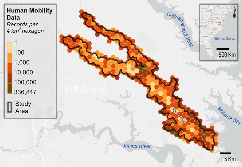
Outdoor recreation is important for improving quality of life, well-being, and local economies, but quantifying its value without direct monetary transactions can be challenging. New research from NOAA’s National Centers for Coastal Ocean Science combines the travel cost method, a non-market valuation technique that uses the time and travel cost expenses that people incur to visit a site as the price of access to that site, with anonymous human mobility data to estimate the value of outdoor recreation for the York River and surrounding parks in Virginia. These spaces encompass a diverse range of habitats, including open fields, marshes, tidal wetlands, forests, and upland areas, and offer a range of recreational activities, such as wildlife watching, picnicking, hiking, biking, and fishing.
Results suggest that the outdoor recreation value of the area was $15.5 million across nearly 600,000 trips observed in 2022. Data indicates peak visitation times are weekends, holidays, and the summer months, with visits being 16% more likely to occur in the summer than in other seasons and 17% more likely to occur on weekends than on weekdays. The vast majority of trips were local, with visitors traveling an average of 20 minutes. Analysis further showed that those with young children, who are Hispanic, or over 64 years old were less likely to visit. Several factors may contribute to this, such as varying time or income constraints and limited public transportation, and warrant a need for targeted efforts to promote accessibility for a broader range of communities.
The study found that the use of human mobility data, which is GPS-derived and continuously logged, provides comparable visitation estimates to observation counts and surveys. The data is anonymous and readily available, allowing policymakers and managers to use insights from data analysis to make informed and sustainable choices in outdoor recreation management. This study is one of the first to use human mobility data to assess recreational use, and sheds light on the various factors that influence visitation patterns and recreation values.
The next steps from this work will be to deploy pedestrian and vehicle counters in select parks around the York River, as well as administer a random household survey within the surrounding communities to better understand motivations and barriers to outdoor recreation along the York River.