Algal Blooms from Satellite for Tampa Bay
This page shows algal blooms in Tampa Bay. Blooms of some different types of algae may be present. In lower Tampa Bay, Karenia brevis may be present. Satellite imagery with Karenia brevis cell counts can be found at our new harmful algal bloom site for Southwest Florida. Old Tampa Bay may have Pyrodinium bahamense, more information on this potentially harmful algae can be found at the Florida Fish and Wildlife Commission HAB Factsheets. Information on water quality sampling in Tampa Bay can be found at the Florida DEP Tampa bay Sampling site.
(You may need to refresh your browser or clear your browsing data to see the latest forecast.)
The images were derived from Copernicus Sentinel-3 satellite data from the European Organisation for the Exploitation of Meteorological Satellites (EUMETSAT) and were processed by NOAA, National Centers for Coastal Ocean Science.
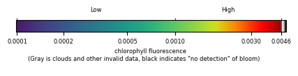
NOTE: Image quality will vary with clouds and satellite position (OLCI satellite background information). See more information about our bloom monitoring imagery.