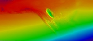
NCCOS scientists aboard the NOAA ship Nancy Foster provided near real-time mapping data to the South Atlantic Fishery Management Council as they considered designating a new special management zone to protect spawning deep-water snapper and grouper. The mapping data provided to the Council, less than 24 hours after the request came in, allowed the Council to adjust the coordinates around the area of interest and resulted in them approving a larger area for further data analysis. The area of interest, named Warsaw Hole, is located southwest of Key West and appears to be an impressive underwater habitat with unique bathymetric features.
The research cruise was primarily focused on completing an assessment of the status of ecological condition and potential stressor impacts in unconsolidated sediments and overlying waters of the Florida Keys National Marine Sanctuaryin support of management needs. In addition, the ship’s multibeam sonar system was used to map bathymetry and backscatter throughout the deeper portions of the sanctuary in support of developing a habitat map of important living marine resources and sensitive habitat areas. This effort highlights the power of partnerships in leveraging resources as well as the ability of NCCOS scientists to respondrapidlyto data requests from the broader NOAA community.
For more infomation contact : Cynthia.Cooksey@noaa.gov, Ch

