Home > Explore News > Reef Fish Movements Tracked in USVI Monument to Assess Boundary Effectiveness

Reef Fish Movements Tracked in USVI Monument to Assess Boundary Effectiveness

Published on: 04/06/2015
Research Area(s): Marine Spatial Ecology
Primary Contact(s): matt.kendall@noaa.gov

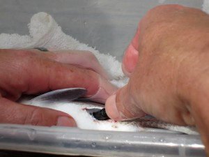
NCCOS and National Park Service (NPS) researchers are evaluating the boundaries of the Virgin Islands Coral Reef National Monument in Coral Bay, St. John relative to the home range of reef fish that the monument was conceived, in part, to protect. The team has tracked reef fish movements using surgically implanted acoustic transmitters and an array of 40 acoustic receivers deployed from 2013 to 2015 inside and outside the monument's boundaries.

diver-retrieving-acoustic-fish-receiver-in-USVI

Diver retrieves acoustic fish receiver submerged for 18 months in Virgin Islands Coral Reef National Monument. Credit: NOAA.

Researcher-implants-acoustic-transmitter-in-reef-fish

Researcher implants acoustic transmitter in reef fish. Credit: NOAA.

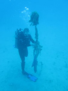
NCCOS and NPS scientists recovered the receivers in March 2015 and downloaded the telemetry data for analysis over the coming months. Results of this collaborative study and others by NCCOS, including reef mapping and fish census data, will be used by the NPS to determinethe effectiveness of the monument's boundaries and for other applications, including an environmental impact review by the National Marine Fisheries Service for marina development proposals in Coral Bay Harbor.

For more information, contact Matt.Kendall@noaa.gov.

Explore Similar News

About NCCOS

NCCOS delivers ecosystem science solutions for stewardship of the nation’s ocean and coastal resources to sustain thriving coastal communities and economies.

Stay Connected

Sign up for our quarterly newsletter or view our archives.

NCCOS Multimedia

Visit our new NCCOS Multimedia Gallery. 

Follow us on Social

Listen to our Podcast

Check out our new podcast "Coastal Conversations"