On April 30, in another step by the Biden-Harris Administration to support the growing momentum across America for a renewable energy economy, the Department of the Interior announced a proposal for offshore wind energy auctions off the coast of Oregon.
 To explain how those proposed sale areas were identified, NCCOS built a StoryMap titled “Finding Space: Siting Oregon’s Wind Energy Areas.” This interactive digital platform offers an in-depth look into the data-driven science that supported the Bureau of Ocean Energy Management (BOEM) in identifying the locations for offshore wind energy development off the coast of Oregon.
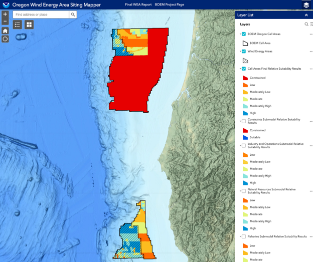
Oregon’s coastline has significant potential for wind energy development, with its sustained ideal wind speeds spanning nearly the entire coastal area. Siting Wind Energy Areas (WEAs) in the ocean requires navigating a myriad of challenges and considerations, including the integration of input from various interested parties such as tribal, federal, state, and local entities, industry representatives, conservation organizations, and the public. The StoryMap sheds light on the comprehensive marine spatial planning process employed by NCCOS to support BOEM in addressing these complexities with the best available data. By assessing more than 30 data layers, NCCOS created a map of the ocean to identify areas that had the least conflict with other ocean users.
The StoryMap explains the marine spatial planning process and gives users the opportunity to explore the data for themselves in the interactive MapViewer. The goal is to offer a detailed glimpse into the wealth of data used in the spatial modeling process, ranging from fisheries and protected species, to industry and wind speeds.
These two WEAs off the coast of Oregon – one in Coos Bay and the other in Brookings – were identified through comprehensive spatial modeling, an approach which works to reconcile user and natural resource conflicts, and public engagement. Visit the Department of the Interior’s press release for more information.