Fisheries and coastal zone managers depend on fine scale bathymetry and habitat maps for critical management decisions, yet within NOAA’s Channel Islands National Marine Sanctuary (CINMS), a large part of the seafloor remains un-mapped and unexplored.
From April 26th to May 11th, teams from CINMS, the National Centers for Coastal Ocean Science, Office of Coast Survey, the University of New Hampshire, and Marine Applied Research and Exploration were aboard NOAA’s research vessel Bell M. Shimada to map and explore the sanctuary. The cruise included autonomous underwater vehicle (AUV) mapping, remotely operated vehicle (ROV) exploration, and ship-based seafloor mapping, along with fisheries acoustics surveys.
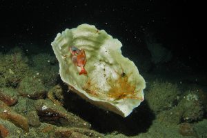
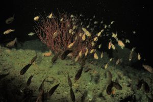
The mission completed fourteen successful ROV dives in nine days, covering 19.5 km. The ROV dive team explored the rim of Santa Cruz Canyon and two new ridge features southeast of Santa Rosa Islands. The ROV collected stunning photos and videos of 6-Gill sharks, Lophelia corals, Antipathes black corals, rockfishes, and Great Pacific octopuses (see video below of octopus found during the mission 100 meters deep in the Santa Cruz Canyon).
Seafloor mapping included eight AUV deployments which mapped 20 nautical square milesof seafloor. An additional 61 nautical square miles of seafloor was mapped with the ship-based, ME70 sonar. This data will be used to fill gaps in Sanctuary maps, characterize seafloor habitat, and help inform management decisions within and around CINMS.
For more information from NCCOS contact: Laura Kracker ( Laura.Kracker@noaa.gov ) or Peter Etnoyer ( peter.etnoyer@noaa.gov) . For more information on Channel Islands NMS contact: Chris Caldow ( chris.caldow@noaa.gov ) or Ryan Freedman ( ryan.m.freedman@noaa.gov ).