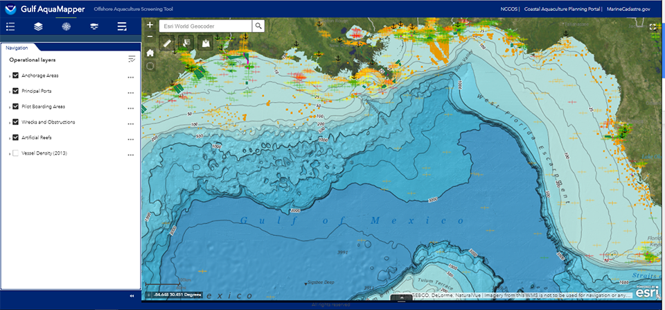
NCCOS is excited to release the newly created Gulf AquaMapper, a web-based tool for exploration, permitting and siting of offshore aquaculture in the Gulf of Mexico. The Gulf AquaMapper is a geodatabase featuring aquaculture-relevant GIS data for biological, navigational, military, social, economic, physical and chemical parameters. The Gulf AquaMapper can be used as a one-stop screening solution for industry and coastal managers focused on identifying suitable areas for aquaculture development. With over 50 data types, the Gulf AquaMapper is the first spatial planning tool designed specifically for aquaculture in the Gulf of Mexico. In particular, the tool aims to streamline the permitting process established by the Gulf of Mexico Fishery Management Council in 2016, by reducing logistical and economic inefficiencies for coastal managers and aquaculture investors. Multiple data layers can be viewed simultaneously for a more comprehensive assessment of competing uses, and maps can be printed and shared to inform a more detailed site assessment to verify environmental conditions and establish site-specific designs.
This product was developed in partnership with marinecadastre.gov, and similar products are in development for other regions across the United States.
The Gulf AquaMapper is one of many coastal planning tools designed to assist managers, planners, and industry with sustainable aquaculture development, all of which can be found on NCCOS’s Coastal Aquaculture Planning Portal.
For more information, contact James.Morris@noaa.gov.