In September 2019, a multi-disciplinary team of NCCOS scientists and colleagues completed a successful mission aboard the NOAA Ship Nancy Foster studying the ecological function of shipwreck and rocky reef habitats off North Carolina.
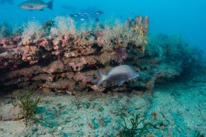
During the mission, scientific divers visited a selection of shipwrecks and rocky reefs ranging from 20 – 35 meters deep. On each habitat, divers surveyed fish communities with underwater visual transects counting, identifying, and estimating the size of both conspicuous and cryptic fishes. Divers observed a diversity of fishes, including gag, scamp, amberjack, almaco jack, white grunt, tomtate, vermillion snapper, yellowtail snapper, lionfish, French angelfish, and more.
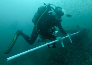
While underwater, dive teams swam over the reefs in grid and zig-zag patterns collecting thousands of images from downward facing camera arrays. The images will later be stitched together to create photomosaics or 3D models of the reefs. These models will be used to visualize each reef and also calculate measures of reef complexity and benthic invertebrate and macroalgae cover.
Between dives and overnight, the team used multibeam and splitbeam echosounders to map the habitats and associated fish. The resulting echosounder data will be paired with diver-collected data to test how fish biomass and spatial distributions differ between shipwrecks and rocky reefs. Together, the diver and echousounder data provide information on how shipwrecks and rocky reefs function to provide habitat for a diversity of fish, ultimately helping ensure that reefs and their fish remain healthy.
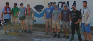
The research mission was led by NCCOS with Chris Taylor (NCCOS Biogeography) serving as chief scientist. The science team included: Andrew Mason (NCCOS Monitoring & Assessment), Avery Paxton (NCCOS Biogeography/CSS, Inc.), Brian Degan (NCCOS Coastal Resilience & Restoration), Brendan Guthrie (NCCOS Biogeography/CSS inc.), Cory Ames (NCCOS Biogeography/CSS, Inc.), Dave Sybert (Coastal Studies Institute/East Carolina University), Erik Ebert (NCCOS Biogeography/CSS, Inc.), LTJG Jennifer Kraus (NOAA Corps/NCCOS Biogeography), Justin Boeck (NOAA Southeast Fisheries Science Center), Mike Bollinger (NCCOS Biogeography/CSS, Inc.), and Sean Morton (NCCOS Hollings Marine Lab).
The mission was supported by the officers and crew of the NOAA Ship Nancy Foster. Real-time marine forecasting was provided by the National Weather Service Forecast Office Newport/Morehead City, NC.