NCCOS scientists recently evaluated new, benthic habitat mapping technologies and methods during a five-day mission at Flat Cay in St. Thomas, USVI. Benthic habitats in the Caribbean – including, coral reefs, seagrass beds, and mangroves – provide many important ecosystem services, such as fishing, tourism, and shoreline protection. Accurate maps of these habitats are integral to their management.
The team is investigating whether waveform metrics (e.g., peak amplitude, standard deviation, skewness, and area under the curve) derived from airborne bathymetric Light Detection and Ranging (LiDAR) data can improve NCCOS’s benthic habitat mapping capabilities. LiDAR systems function by emitting pulses of light energy toward a surface and recording the elapsed time between emission and return of each pulse. To date, few investigators have explored the utility of waveform metrics for seafloor mapping applications.
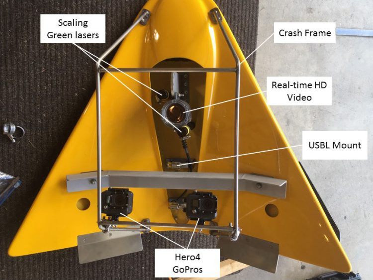
The researchers conducted in situ surveys using an underwater tow-wing (shown above) and SCUBA divers. The tow-wing was outfitted with dual scaling lasers, a depth sensor, dual GoPro cameras, and a forward looking video camera. The divers had GoPro cameras and hand-held depth sensors that measured seafloor rugosity (surface roughness) as well as canopy height. The divers also collected information on marine organismspresent. The team will use the data collected by the tow-wing and the divers to generate photo mosaics and digital elevation models of the seafloor.
Next, thein situ information will be linked with LiDAR waveform metrics (from data collected by USGS in 2014) to better understand whether waveform metrics can be used to develop more resolved benthic habitat maps. This research is anticipated to advance techniques to process and use waveform metrics for habitat mapping, provide new tow-wing observation tools to characterize large areas of the seafloor more efficiently, develop software protocols that allow for more effective characterization of seafloor habitats, and implement more accurate seafloor rugosity measurements.
The project is being conducted in collaboration with Oregon State University’s School of Civil and Construction Engineering’s Geomatics Program and the University of New Hampshire’s Center for Coastal and Ocean Mapping/Joint Hydrographic Center.
For more information, contact Tim.Battista@noaa.gov or Bryan.Costa@noaa.gov.